 Wir fahren weiter am in den Wolken verborgenen Popocatepetl vorbei nach Teotihuacán. Dieser Ort im Zentralen Hochland von Mexiko liegt nördlichen Rand der Metropole México City und ist eine der bedeutendsten prähistorischen Ruinenmetropolen Amerikas, die vor allem für ihre Stufentempel wie die große Sonnenpyramide bekannt ist. Die archäologische Stätte, die seit dem Jahr 1987 zum Weltkulturerbe der UNESCO gehört, liegt im Bundesstaat México in der Nähe der heutigen Stadt Teotihuacán de Arista, etwa 45 km nordöstlich von Mexiko-Stadt. Das Gebiet von Teotihuacán war bereits seit dem 6. Jahrhundert v. Chr. permanent bewohnt. Zwischen 100 und 650 n. Chr. – auch bedingt durch den Untergang von Cuicuilco – bildete die Stadt das dominierende kulturelle, wirtschaftliche und militärische Zentrum Mesoamerikas. Auf dem Höhepunkt ihrer Entwicklung hatte sie vermutlich um die 100.000 Einwohner; sie war zu ihrer Zeit neben Caracol die größte Stadt auf dem amerikanischen Kontinent und eine der größten der Welt. Ab etwa 650 schwand ihre Bedeutung, bis sie um 750 aus nicht vollständig geklärten Gründen weitgehend verlassen wurde. Die Azteken fanden Teotihuacan bei ihrer Einwanderung ins Hochland von Mexiko im 14. Jahrhundert bereits als Ruinenstadt vor, die seit Jahrhunderten verlassen war. Sie sahen in ihr einen mythischen Ort und gaben ihr den bis heute fortlebenden Namen Teotihuacan, der so viel bedeutet wie Wo man zu einem Gott wird.
Die Stadt Teotihuacán nahm auf dem Höhepunkt ihrer Entwicklung eine Fläche von mehr als 20 km² ein. Die Anlage der Stadt erfolgte auf der Grundlage einer Rasteranordnung, die genauestens befolgt wurde. So wurde etwa auch der Rio San Juan, der die Stadt durchfließt, durch Kanalisierung dem Raster angepasst.
Die Hauptachse der Stadt bildet die sogenannte Straße der Toten, die die Stadt mit einer Abweichung von 15° 30′ nach Osten in Nord-Süd-Richtung durchzieht, jedoch nicht durchgehend, da sie immer wieder durch Treppendämme unterbrochen wird. Das nördliche Ende der Straße bildet die Mondpyramide mit dem ihr vorgelagerten Platz und dem anliegenden Quetzalpapalotl-Palast. Das Zentrum der Stadt bildet die Sonnenpyramide, nach der Großen Pyramide von Cholula die zweitgrößte Pyramide des amerikanischen Kontinents. Vor ihr befindet sich die plataforma adosada („angeschlossene Plattform“), die als Zeremonialplatz gedient haben könnte.
Einen Standplatz für dem Homey finden wir zwischen Gate 1 und 2, fussläufig zur Kulturstätte. Nicht gerade ruhig, die ganze Nacht dröhnen die Hupen der Züge, bellen die Hunde und morgens krähen die Hähne. Wir verbringen den ganzen Ostersonntag in der riesigen Anlage und sind ganz brav bei den Ersten, die eingelassen werden nach der Öffnung der Tore. Der Himmel ist tw mit Wolken bedeckt und meint es so auch gut mit uns. Bleibend die Geräusche der Souvenirhändler mit ihren Tonpfeifen, die Vögelstimmen und am nachhaltigsten in Erinnerung das Fauchen eines Jaguars imitieren können. Den ganzen Tag über verfolgt uns das Jaguargefauche durch die riesige Anlage.
Leider kann die Sonnenpyramide nicht bestiegen werden, die Mondpyramide zumindest teilweise. Dort treffen wir die Berliner Vokalisten, die neben ihren Konzerten die Zeit nutzen und ebenfalls diese Monumente besichtigen. Ergreifend ein kleines Ständchen, welches sie spontan anstimmen in dieser tollen Kulisse.
Der Palast des Quetzalcoatl ist ein prachtvolles, weitläufiges Raumlabyrinth. Der innen verborgene Tempel der gefiederten Schlange wurde immer wieder überbaut. Nach der Pause im Museumsgarten und Besuch des selbigen wartet mit dem extra Tempel der gefiederten Schlange ein weiterer Höhepunkt. Tolle Flachreliefs mit Tlaloc aus Maiskolben mit seitlichem Krokodil. Diese Gottheit symbolisiert Himmel, Erde und Unterwelt, gilt als Gott des Regens und der Fruchtbarkeit. Das Krokodil symbolisiert dabei die Unterwelt. Die Anlage ist wirklich riesig, monumental und sehr beeindruckend, alles ist klar gegliedert, quasi gerastert.
Am nächsten Morgen müssen wir sehr früh raus. Um 5h15 geht unser Taxi, weil wir eine Ballonfahrt gebucht haben. Anfangs noch etwas Hin und Her wegen einer Nachzahlung (ich hatte mein Gewicht zu großzügig bemessen). Das Nachwiegen ergab jedoch – erstaunlicherweise – ein Gewicht unter 95 kg und damit weit weniger als die erlaubten 100 kg. Schon auf der Taxifahrt haben wir viele Ballons auf der Seite liegend gesehen, die zum Start vorbereitet wurden. Wir fuhren zum Startplatz von „We Fly“ und wurden einem Ballon zugeteilt.
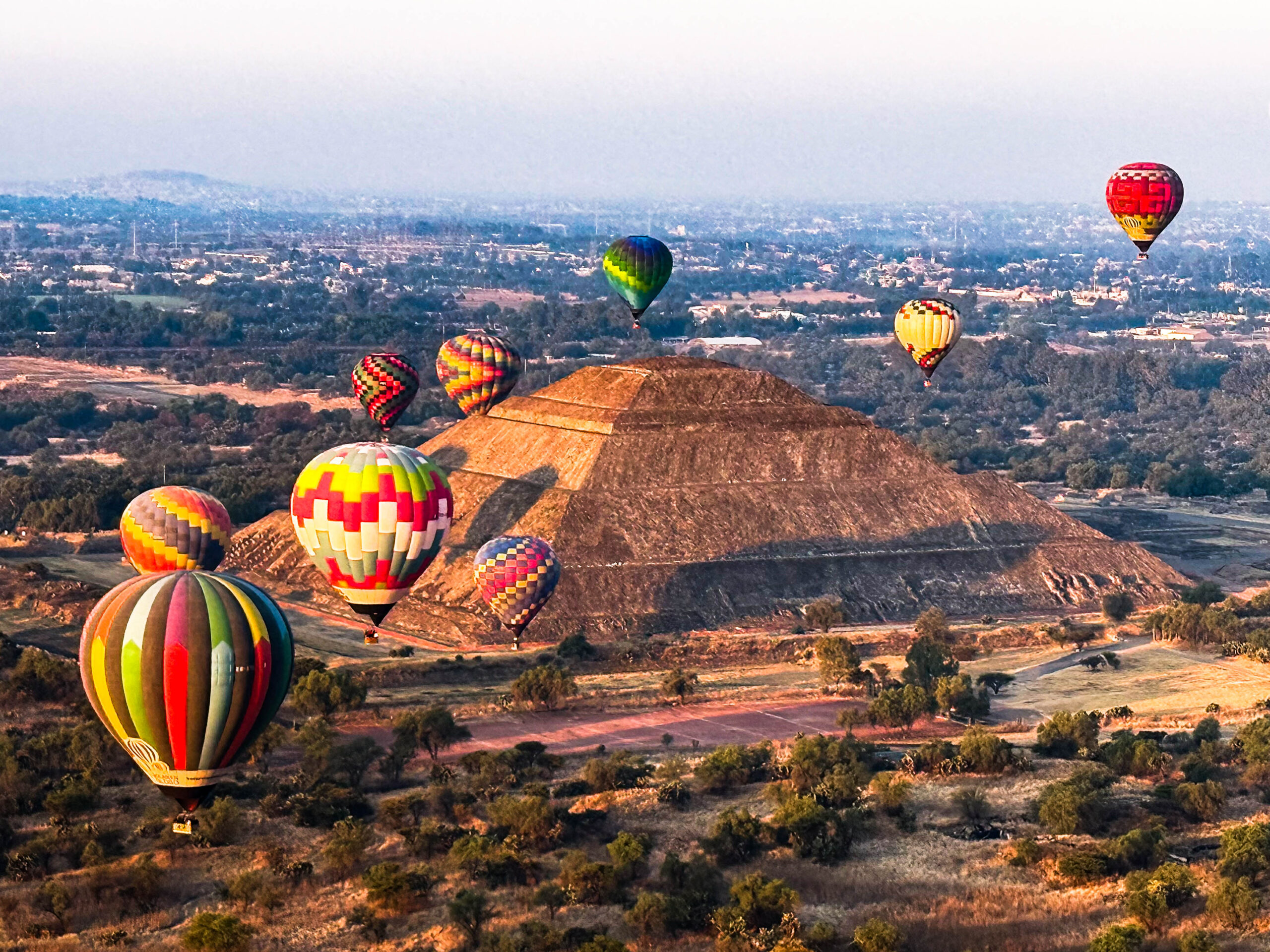
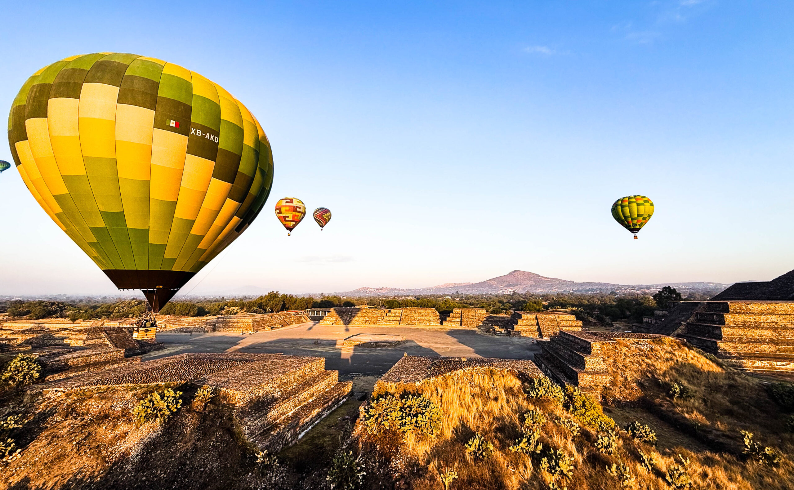
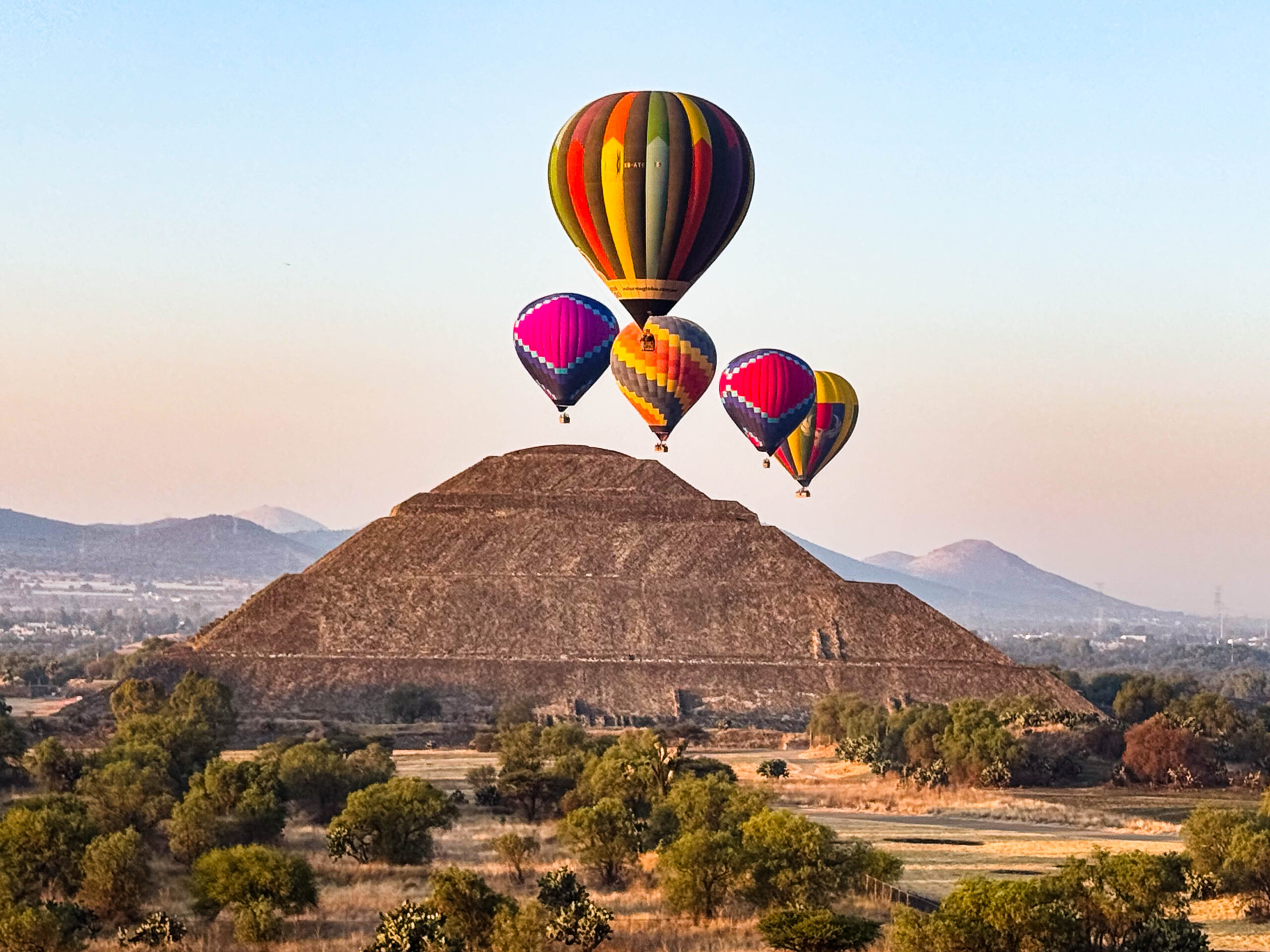
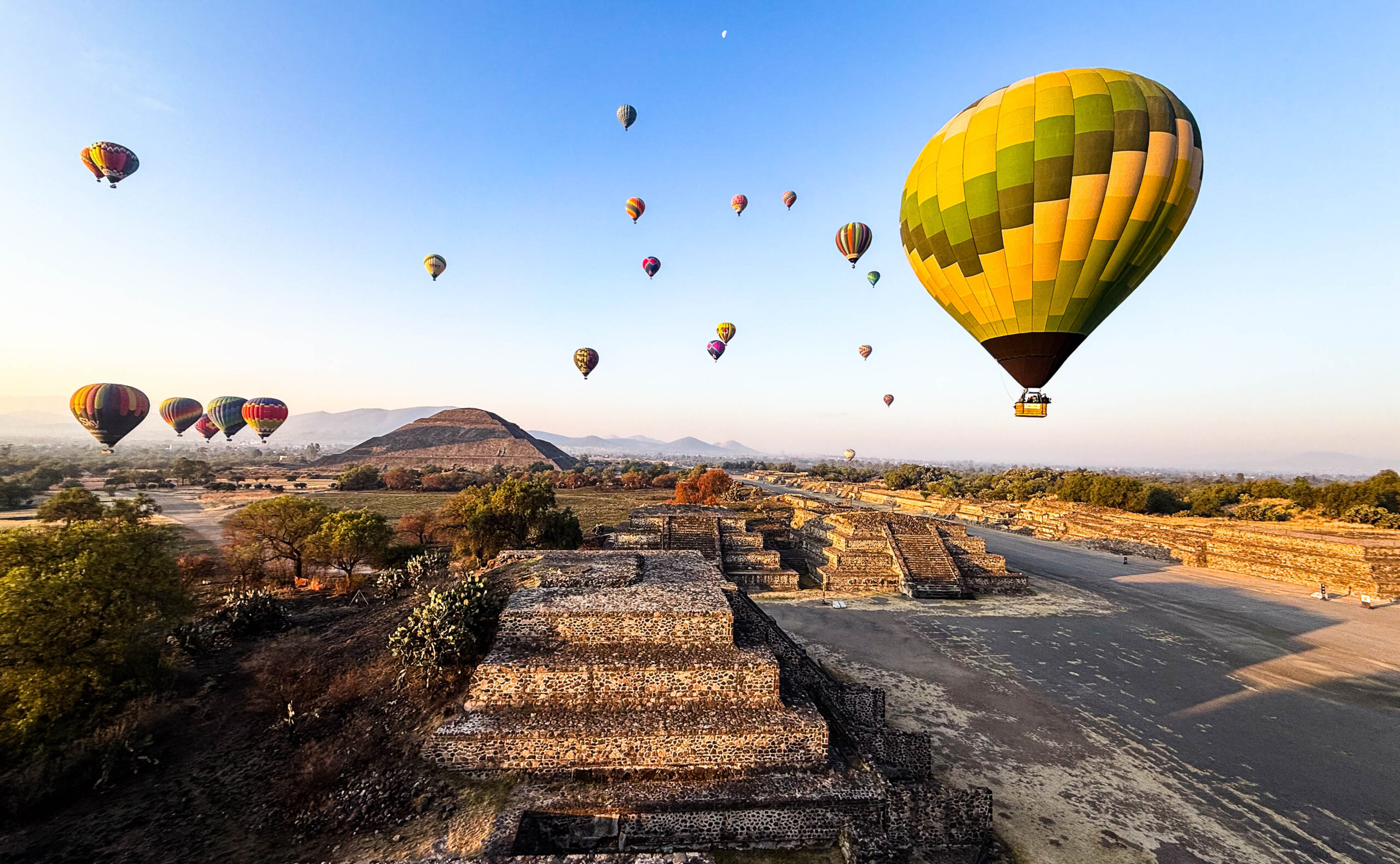
Zum Sonnenaufgang waren wir pünktlich in der Luft, neben uns und in der ganzen Umgebung viele weitere Ballons. Ein sehr grandioser Morgen. Alles gut organisiert und unser Ballonführer/Pilot Antonio Romero brachte es fertig – durch das Ausnutzen verschiedener Höhen – uns über beide Pyramiden schweben zu lassen. Die Landung auf den Punkt, wir wurden mit dem Korb direkt auf den Hänger gezogen. Nach der Rückfahrt zum Zentrum gab’s ein Glas Sekt (blauen Moscato – hat besser geschmeckt als er ausgesehen hat) und das obligate Zertifikat. Beeindruckend und ein sehr schönes Erlebnis mit den vielen Ballons in der Morgenstimmung über den Pyramiden geschwebt zu sein, zumal das Wetter auch so gut mitgespielt hat.
Nach Wasserfassen fahren wir ein Stück zurück auf die „Ruta de los Vulcanos“ und erklimmen die Senke zwischen den Vulkanen Popocatepetl und Iztaccihuatl. Ein neuer Höhenrekord für den Homey, wir stehen auf 3.694m. Die Sicht wird immer besser, bald liegen beide Gipfel frei. Aus dem Popocatepetl steigen Rauchwolken auf. Wegen der vulkanischen Aktivität gilt hier eine Sperrzone, ihn darf man nicht besteigen. Am nächsten Morgen drehen wir eine Runde Richtung Iztaccihuatl zu Wasserfällen, 14km und 400 Höhenmeter. Es fällt uns schwerer als gedacht und wir sind beide froh, als wir wieder am Homey sind. So ganz geht die Höhe dann doch nicht an einem vorbei.
Wir besuchen Cholula nach schöner Talfahrt. Ein Vulkankegel am anderen. Die Pyramide von Cholula ist dem Volumen nach die größte bekannte Pyramide der Welt. Das vorhispanische Bauwerk hat ein Volumen von etwa 4,45 Mio. Kubikmetern mit einer Grundfläche von 450 × 450 m. Allerdings ist es mit der jetzigen Höhe von 66 m deutlich kleiner als die Cheops-Pyramide in Ägypten und auch vier Meter niedriger als die Sonnenpyramide in Teotihuacán. Die Ausgrabungen zeigen jedoch, dass sie früher höher gewesen sein muss. Die oberste der vier Plattformen, auf der jetzt eine Kirche steht, ist sehr groß und auch die untersten Stufen liegen noch einige Meter unter dem heutigen Erdboden. Man vermutet, daß die Pyramide dem Gott Quetzalcoatl (coatl = Schlange, quetzalli = grüne Feder) gewidmet wurde. Von 1931 bis 1956 wurde unter Leitung von Ignacio Marquina ein begehbares Tunnelsystem angelegt. Diese 8 Kilometer langen Tunnel wurden vor allem in das Innere der Pyramide gegraben, um die verschiedenen Überbauungsschichten nachvollziehen zu können. Hierbei wurden mindestens fünf Bauphasen identifiziert. 1966 wurde damit begonnen, Teile des Tempels wieder freizulegen. Heute kann man daher an der West- und Südseite die Pyramide wieder als solche begreifen. Es ist nicht abschließend geklärt, warum die Pyramide heute eher einem dicht bewucherten Berg gleicht als einem Bauwerk von menschlicher Hand. Einige Quellen berichten, dass Hernán Cortés sie zuschütten ließ und mit den Steinen einiger nahegelegener kleinerer Pyramiden die christliche Kirche „Santa Maria de los Remedios“ auf ihr errichten ließ. Andere Berichte sagen, dass die Pyramide bei Cortés’ Ankunft bereits nicht mehr als solche erkennbar war und er diese deshalb auch nicht zerstörte. Von der Kirche hat man einen schönen Blick auf die Vulkangipfel in gut 40 km Entfernung.
Wir machen eine ausführliche Besichtigung, mittags Kirche, am nächsten Morgen dann Museum und Ausgrabung. Ab mittags auf die Nordumfahrung von Mexiko City. Extrem schlechte Strassenverhältnisse, obwohl gerade mal 15 Jahre in Betrieb. Schlaglöcher ohne Ende und dann wird noch Straßenmaut erhoben. Geplant war bis Tula zu fahren, doch alles kommt anders.
Aus nicht nachvollziehbaren Gründen beschließen wir am Rand des Highway zu halten und bei der Inspektion stelle ich fest, dass wir Öl verlieren. Kontinuierlich, Tropfen für Tropfen. 15 km wären es bis zur nächsten Tankstelle, aber beim Wiederanlassversuch des Motors, wird kein Öldruck mehr aufgebaut. Als ich nochmals aussteige sehe ich nun eine große Öllache unter dem Motor.
Eigentlich wollten wir am übernächsten Tag zu Matthias Heyer und seiner Werkstatt unter dt. Leitung zur Inspektion fahren. Wir bekommen über die Notfallnummer kein Service, auch haltende Trucks bekommen keine Verbindung. Schließlich erreichen wir Matthias (gerade in Texas), der besorgt uns einen lokalen Abschleppdienst, der uns zu ihm in die Werkstatt fährt. Soviel Glück gerade im richtigen Moment gehalten zu haben und das Matthias uns den Abschlepper besorgen konnte – unfassbar. Dies hat zur Folge, daß wir die nächsten 2w in San Miguel de Allende verweilen. Zunächst in der Werkstatt, der Ölfilter hatte sich gelöst, dann warten wir auf Ersatzteile in der Stadt, die uns sehr gut gefällt.
Wir parken quasi zentral und bewegen uns zu Fuß oder mit Taxi durch die City. Viel Kunsthandwerk, Museen und Kirchen. Sehr viele Nordamerikaner und Kanadier hier, schöne Geschäfte und Restaurants, nicht billig, eher hochpreisig. Wir besuchen die Ausstellung des privaten Maskensammlers Bill Levasseur, Amerikaner und seit >35a in Mexiko. Er hat mittlerweile ein Bed & Breakfast Hotel errichtet – neu, aber auf alt getrimmt – wunderschön. Die Sammlung ist in einen extra Haus untergebracht, klasse. Daneben ist der hoch am Hang liegende botanische Garten sehenswert. Die Wartezeit bis die Ersatzteile eintreffen verbringen wir auf einem wenige Kilometer stadtauswärts liegenden privaten Campground. Dank Markus Gruse, Offroad Motorhomes, erreichen uns die Teile pünktlich und können problemlos ausgetauscht werden.
Wir haben uns in dieser Woche viele Gedanken gemacht und letztendlich beschlossen, wieder in die USA zu fahren und im Winter zurück nach Europa, via Halifax oder Baltimore je nach Ermessen der Grenzer. Ggf. Verschiffen wir nach noch einem Sommer Nordamerika nach Südamerika oder nehmen den Homey gleich mit zurück nach Europa. Es wird sich zeigen in den nächsten Monaten. Momentan sind wir einfach Mexiko müde, trotz unserer vielen und tollen Erlebnisse hier.
So fahren wir nach einem erneuten sehr erfolgreichen Besuch der Werkstatt von Matthias Heyer – sehr zu empfehlen – Richtung Norden. Wir wollen bei Ojinaga über die Grenze und dann in den Big Bend NP in Texas. Wir sind sehr gespannt, was uns an der Grenze erwartet. Wenn wir erneute 6m Aufenthaltserlaubnis bekommen, werden wir eine Schleife über Colorado zur Oregoncoast mit Besuch von Napa-Valley und den Weingütern einplanen.
[07. Mai 26: Grenze Ojinaga 74.139 km. (In Mexiko gefahren 6.357 km]
 We continue past Popocatepetl, shrouded in clouds, on our way to Teotihuacán. Located in the Central Highlands of Mexico on the northern outskirts of Mexico City, this site is one of the most significant prehistoric ruin complexes in the Americas, known above all for its stepped pyramids, such as the Great Pyramid of the Sun. The archaeological site, which has been a UNESCO World Heritage
Site since 1987, is located in the state of Mexico near the modern-day city of Teotihuacán de Arista, about 45 km northeast of Mexico City. The Teotihuacán area has been continuously inhabited since the 6th century B.C. Between 100 and 650 CE—partly due to the decline of Cuicuilco—the city served as the dominant cultural, economic, and military center of Mesoamerica. At the height of its development, it likely had around 100,000 inhabitants; in its time, it was the largest city on the American continent alongside Caracol and one of the largest in the world. From around 650, its importance waned until it was largely abandoned around 750 for reasons that remain unclear. When the Aztecs migrated to the highlands of Mexico in the 14th century, they found Teotihuacan already in ruins, having been abandoned for centuries. They viewed it as a mythical place and gave it the name Teotihuacan, which has survived to this day and means “Where one becomes a god.”
At the height of its development, the city of Teotihuacan covered an area of more than 20 km². The city was laid out according to a grid pattern that was strictly adhered to. For example, the Río San Juan, which flows through the city, was channeled to fit the grid.
The city’s main axis is formed by the so-called Avenue of the Dead, which runs north-south through the city with a deviation of 15° 30′ to the east, though not continuously, as it is repeatedly interrupted by terraced ramps. The northern end of the avenue is marked by the Pyramid of the Moon, with the plaza in front of it and the adjacent Quetzalpapalotl Palace. The center of the city is the Pyramid of the Sun, the second-largest pyramid on the American continent after the Great Pyramid of Cholula. In front of it is the plataforma adosada (“attached platform”), which may have served as a ceremonial plaza.
We find a spot for the Homey between Gates 1 and 2, within walking distance of the archaeological site. It’s not exactly quiet—all night long the trains’ horns blare, dogs bark, and in the morning the roosters crow. We spend the entire Easter Sunday in the vast complex and are among the first to be let in after the gates open. The sky is partly cloudy and is being kind to us. The sounds of the souvenir vendors with their clay pipes, the birdsong, and—most memorably—the ability to imitate a jaguar’s hiss linger. The jaguar’s hiss follows us through the vast complex all day long.
Unfortunately, the Pyramid of the Sun cannot be climbed, but the Pyramid of the Moon can, at least partially. There we meet the Berlin Vocalists, who are using the time between their concerts to visit these monuments as well. It’s moving to hear the little serenade they spontaneously strike up against this magnificent backdrop.
The Palace of Quetzalcoatl is a magnificent, sprawling labyrinth of rooms. The Temple of the Feathered Serpent, hidden inside, has been rebuilt time and again. After a break in the museum garden and a visit to the museum itself, another highlight awaits: the separate Temple of the Feathered Serpent. Amazing bas-reliefs featuring Tlaloc made of corn cobs with a crocodile on the side. This deity symbolizes heaven, earth, and the underworld, and is considered the god of rain and fertility. The crocodile symbolizes the underworld. The complex is truly huge, monumental, and very impressive; everything is clearly structured, almost grid-like.
The next morning we have to get up very early. Our taxi leaves at 5:15 a.m. because we’ve booked a hot-air balloon ride. At first there was some back-and-forth about an additional payment (I had estimated my weight too generously). However, the reweighing revealed—surprisingly—a weight under 95 kg, and thus far less than the allowed 100 kg. Already on the taxi ride, we saw many balloons lying on their sides, being prepared for takeoff. We drove to the launch site of “We Fly” and were assigned a balloon.
We were in the air right on time for sunrise, with many other balloons beside us and all around. A truly magnificent morning. Everything was well organized, and our balloon guide/pilot, Antonio Romero, managed—by utilizing different altitudes—to have us float over both pyramids. The landing was spot-on; we were pulled directly onto the trailer with the basket. After the return trip to the center, we were treated to a glass of sparkling wine (blue Moscato—tasted better than it looked) and the obligatory certificate. It was an impressive and truly beautiful experience to float above the pyramids in the morning light among so many balloons, especially since the weather cooperated so well.
After filling up on water, we drive back a short distance onto the “Ruta de los Vulcanos” and climb up the valley between the Popocatepetl and Iztaccihuatl volcanoes. A new altitude record for the Homey—we’re at 3,694 meters. The view keeps getting better; soon both peaks are clearly visible. Clouds of smoke rise from Popocatepetl. Due to volcanic activity, there’s a restricted zone here; you’re not allowed to climb it. The next morning, we head toward Iztaccihuatl to see some waterfalls—a 14-kilometer hike with a 400-meter elevation gain. It’s harder than we expected, and we’re both glad to be back at the Homey. The altitude really does take its toll.
We visit Cholula after a beautiful descent. One volcanic cone after another. The Pyramid of Cholula is the largest known pyramid in the world by volume. The pre-Hispanic structure has a volume of approximately 4.45 million cubic meters with a base area of 450 × 450 m. However, at its current height of 66 m, it is significantly smaller than the Pyramid of Cheops in Egypt and also four meters lower than the Pyramid of the Sun in Teotihuacán. Excavations show, however, that it must have been taller in the past. The topmost of the four platforms, on which a church now stands, is very large, and even the lowest steps lie several meters below today’s ground level. It is believed that the pyramid was dedicated to the god Quetzalcoatl (coatl = snake, quetzalli = green feather). From 1931 to 1956, a navigable tunnel system was constructed under the direction of Ignacio Marquina. These 8-kilometer-long tunnels were dug primarily into the interior of the pyramid to trace the various layers of construction. At least five construction phases were identified in the process. In 1966, work began to uncover parts of the temple. Today, therefore, the pyramid can once again be recognized as such on the west and south sides. It remains unclear why the pyramid today resembles a densely overgrown mountain rather than a man-made structure. Some sources report that Hernán Cortés had it filled in and used the stones from several nearby smaller pyramids to build the Christian church “Santa María de los Remedios” on top of it. Other accounts state that the pyramid was already unrecognizable as such by the time Cortés arrived, and that is why he did not destroy it. From the church, there is a beautiful view of the volcanic peaks some 40 km away. We take a thorough tour, visiting the church at noon and the museum and excavation site the next morning.
Starting at noon, we head out on the northern bypass of Mexico City. Extremely poor road conditions, even though the highway has only been in use for 15 years. Endless potholes, and to top it off, they charge a toll. The plan was to drive to Tula, but things turned out differently.
For reasons we couldn’t fathom, we decided to pull over to the side of the highway, and upon inspection, I noticed we were losing oil. Continuously, drop by drop. It would be 15 km to the next gas station, but when we try to restart the engine, no oil pressure builds up. When I get out again, I now see a large oil puddle under the engine.
We had actually planned to drive to Matthias Heyer and his German-run workshop the day after tomorrow for an inspection. We can’t get any service through the emergency number, and even trucks that have pulled over can’t get through. Finally, we reach Matthias (who’s currently in Texas), and he arranges for a local tow truck to take us to his workshop. We were so lucky to have stopped at just the right moment and that Matthias was able to get us the tow truck—it’s unbelievable. As a result, we’ll be staying in San Miguel de Allende for the next two weeks. First at the shop—the oil filter had come loose—then we wait for replacement parts in the city, which we really like. We park pretty much downtown and get around on foot or by taxi. Lots of arts and crafts, museums, and churches. Lots of North Americans and Canadians here, nice shops and restaurants, not cheap, more on the expensive side. We visit the exhibition of a private mask collector, Bill Levasseur, an American who has been in Mexico for over 35 years. He has since built a bed-and-breakfast hotel—new, but designed to look old—it’s beautiful. The collection is housed in a separate building, which is fantastic. Next to it, the botanical garden perched high on the hillside is well worth a visit.
We spend the waiting time until the replacement parts arrive at a private campground a few kilometers outside of town. Thanks to Markus Gruse, Offroad Motorhomes, the parts arrive on time and can be replaced without any issues.
We’ve given it a lot of thought this week and ultimately decided to drive back to the U.S. and return to Europe in the winter, via Halifax or Baltimore, depending on the border agents’ discretion.
[May 7, 2026: Ojinaga border, 74,139 km. (Drove 6,357 km in Mexico)]