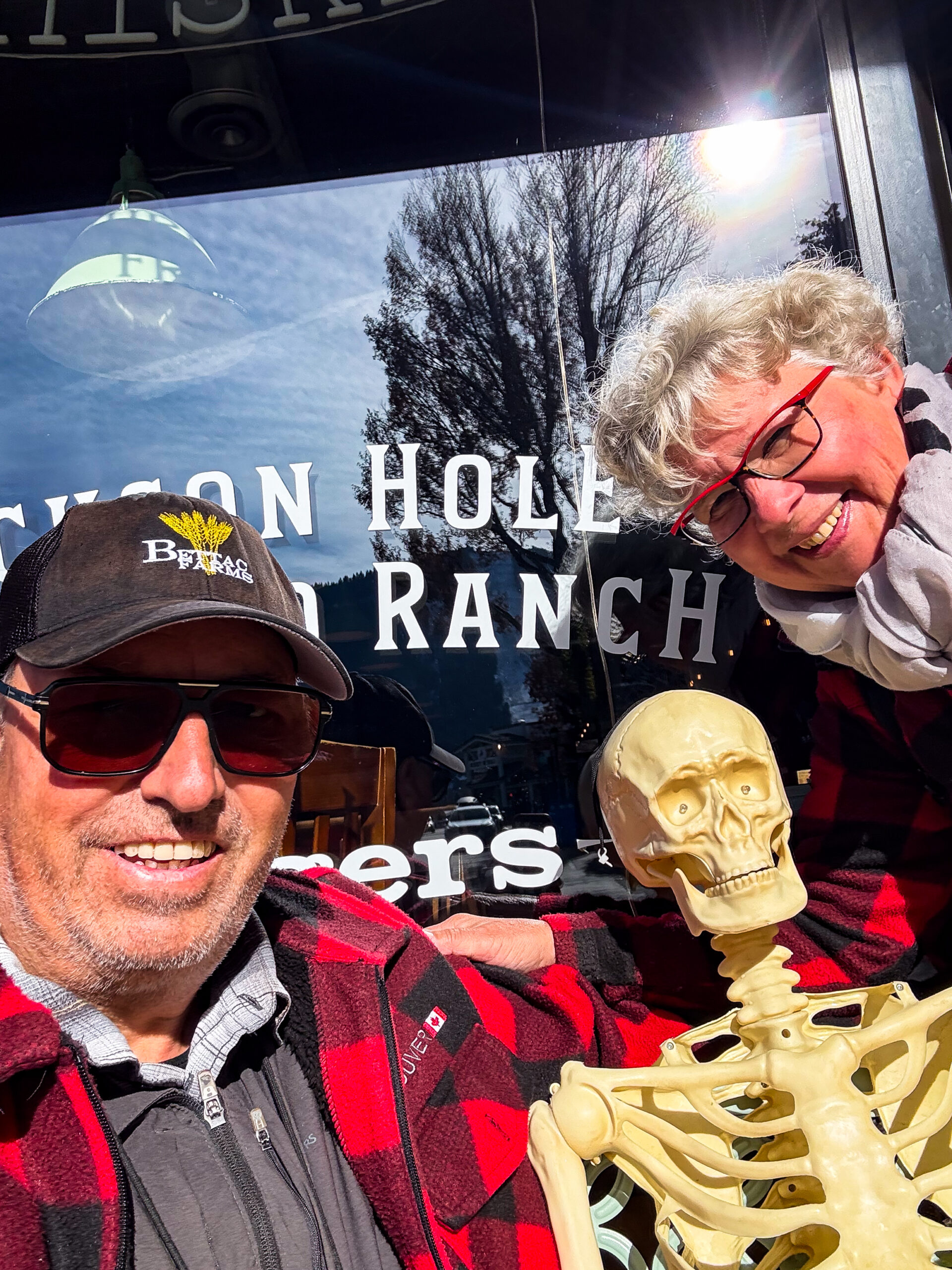
Durch die Nationalparks des mittleren Westens – USA-Loop 3
 unsere erneute Einreise in die „lower 48“ gestaltet sich völlig unproblematisch. Sehr beeindruckend der Monolith des Chief Mountain. Wir steuern den NP Campground in St.Mary an. Der aktuelle „shutdown“ erschwert Buchung und Zahlungen beim Parkeintritt, daneben Sturm- und Schneewarnung für den Glacier NP Ost, Böen bis zu 80 Miles/h werden erwartet, wir parken in Windrichtung und beschließen, das Wetter auszusitzen. Nachts schüttelt es den Homey anständig durch. Nachdem Aussitzen fahren wir die Many Glacier Rd. Schönes Bergpanorama, mächtige Felsmassive. Wir sehen Mountain Goats und kurz darauf 3 Grizzlys (Mutter mit zwei blonden cubs). Wanderung zu den Red Rock Falls und später noch zu den Swiftcurrent Falls. Leider ist die „Going-to-the-sun-Rd“ schon jahreszeitlich bedingt geschlossen, der noch befahrbare Weg sehr schön.
Uns zieht es gen Yellowstone und in den Süden. Wir passieren einen Blackfoot-Viewpoint mit Metallkonstruktionen, die an Tipis erinnern sollen, schöne Blicke. Über 1833m geht’s nach Browing, leider ist das Museum der Plains Indian wegen dem „shutdown“ geschlossen.
Wir fahren weiter durchs Blackfoot-Land, treffen wieder auf den Lewis & Clark Trail und das Missile Field – wir sind nahe Great Falls und unserer letztjährigen Route. Die Bynum Reservoir Recreation Area bietet einen perfekten Stellplatz für die Nacht, schöne Abendstimmung und toller Sternenhimmel.
Es wird hügeliger und bergiger. Wir fahren über Helena und Bozeman. Das Museum of the Rockies zeigt hiesige Dino-Funde und eine aktuelle Ausstellung anlässlich des Todes von Jane Goodall zu ihrem Lebenswerk. Bummel durch die schöne Mainstreet mit ihren Backsteinbauten, tolles Teegeschäft, leider astronomische Preise (113g/28$). Später Email von Rob Sisson, Kappelrodecker Familie.
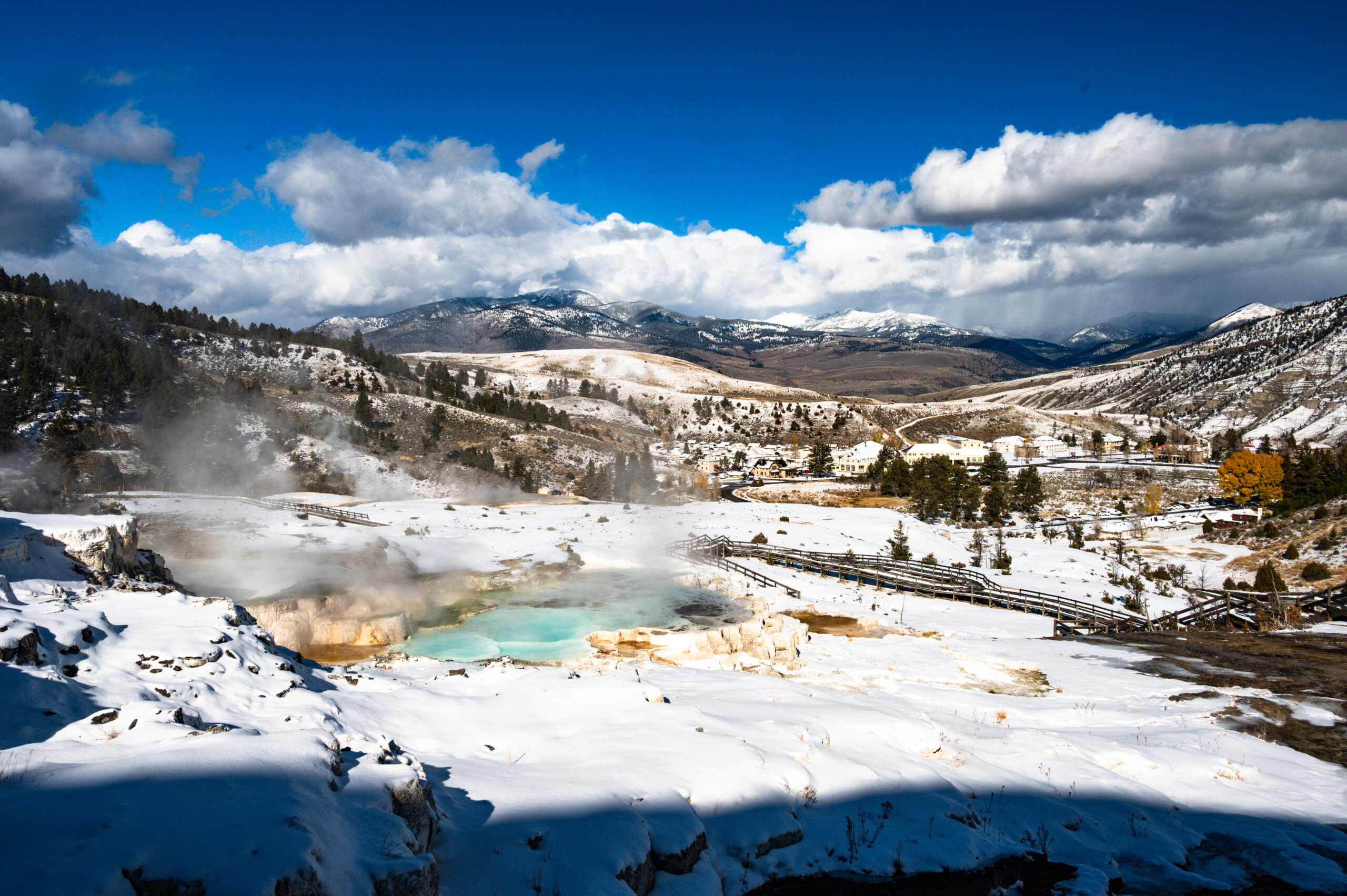
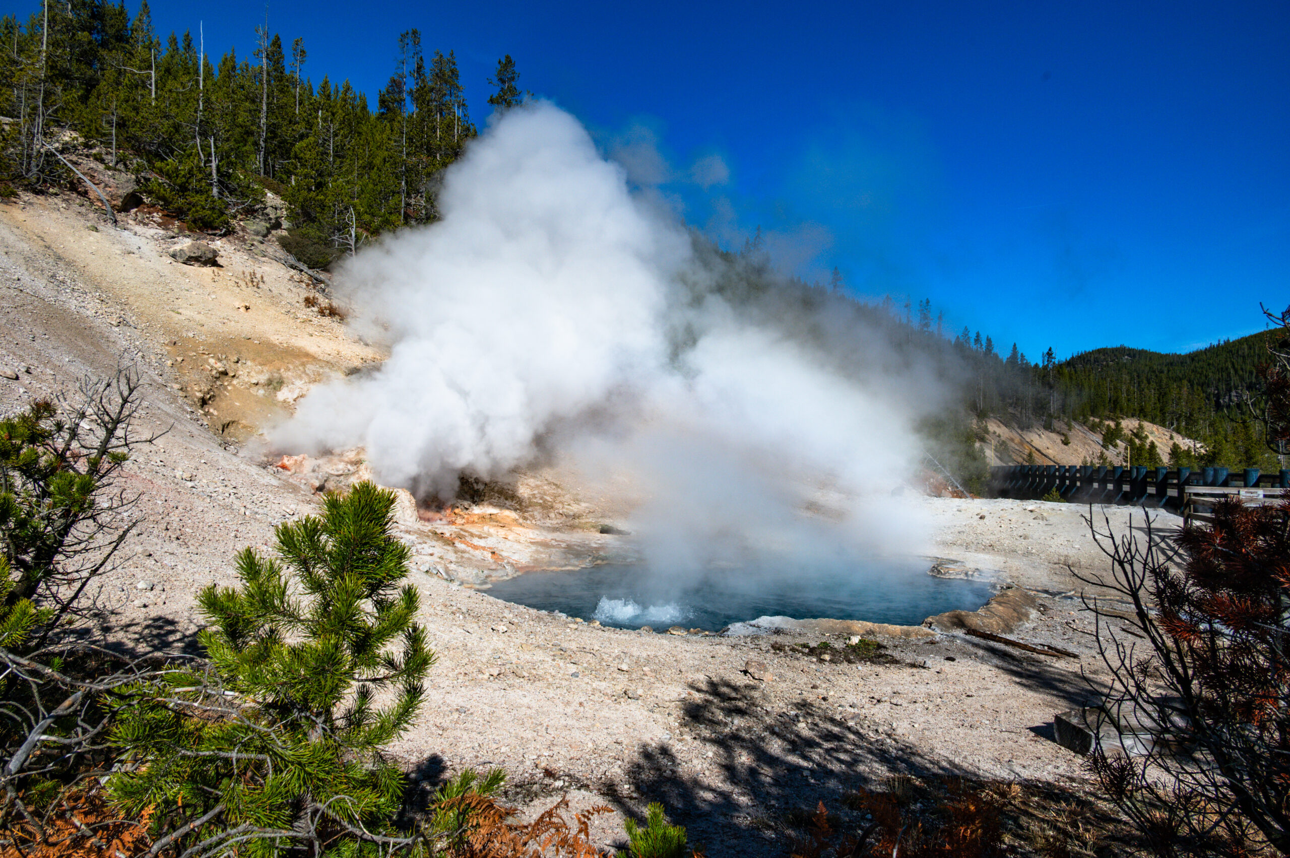
Die letzte Oktoberwoche verbringen wir im Yellowstone NP und sind total begeistert. Leider ist nur noch ein Campingplatz bei Mammoth geöffnet, einer historischen Garnisonsanlage, die heute eher wie eine gepflegte Kurstadt wirkt. Bei schönstem Wetter (kalt mit klarem, blauem Himmel) durchfahren und durchwandern wir den NP. Wir sind überrascht von den vielfältigen vulkanischen Aktivitäten, es blubbert, zischt, brodelt, riecht nach Schwefel – spektakuläre Bilder. Am Old Faithfull verpassen wir den Ausbruch um wenige Minuten, wir drehen um und fahren zurück und erleben den Grand Canyon Artist Point in der Abendstimmung, zuvor über die Continental Divide (2.600 m, Rekordhöhe des Homey bislang). Im Hayden Valley weiden Bisons im ganzen Tal verteilt. Nachdem wir nun einen festen Platz auf dem Campground buchen konnten, fahren wir am nächsten Tag den Dunraven Pass. Er ist mit 8859 ft bzw. 2700 m der höchste Punkt der Grand Loop Rd. Der Pass ist nach dem Engländer Earl of Dunraven benannt, der 1874 eine Expedition in die Rocky Mountains unternahm, und verbindet den Ort Tower im Norden mit Canyon Village im Süden. Wieder eine Rekordhöhe für den Homey. Wir laufen verschiedene Loops auf dem Grand Canyon North Rim, unter anderem auch zu den Lower Falls und dem Red Rock Point. Überall Rhyolithgestein, der namensgebende Yellowstone findet sich erst weit im Osten Montanas am Flussufer. Aufkommender Wind und Wolken kündigen den kommenden Blizzard an, den wir auf dem Campingplatz aussitzen. Nun ist alles weiß und kalt (-10 °C) und wir erkunden das Lamar Valley. Die Donraven Passstraße ist tatsächlich wegen Schnee nach den Towe Falls gesperrt. Wir besuchen den „Petrified Tree“, sehen Wapitis, Elche, Schwarzschwanzhirsche, viele Bisons, Kojoten und schwarze Wölfe. Letztere jedoch nur durch die starken Optiken der „Wolfsspäher“, die mit ihren Optiken den Tieren den ganzen Tag folgen. Sie haben dafür Stühle und Stative aufgebaut und erklären bereitwillig, was man wo und wie erkennen kann und zeigen Schnappschüsse, die sie mit speziellen Vorrichtungen mit dem Handy aufgenommen haben. Mit dem unbewaffneten Auge erkennt man allenfalls weit entfernte schwarze Punkte.
Am nächsten Tag nochmals im Lamar Valley unterwegs zum „petrified forest“, sehr schön aber auch sehr anstrengend, tw. steil, matschig und rutschig durch den aufgeweichten Boden und den Schnee. Bären- und Wolfsspuren, jedoch keine der Tiere zu sehen, über den Hang verteilt mehrere versteinerte Baumstämme – der Lohn der Mühe. Bei der Rückfahrt sehen wir wieder den bettelnden Kojoten vom gestrigen Tag, später noch einen zweiten.
Am vorletzten Parköffnungstag fahren wir ganz nach Süden, passieren die große Wapitiherde heute ganz im Sagebrush. Überall die dampfenden Geysire, Gewässer und Bachläufe nun in tief verschneiter Landschaft. Artist Paintpols, Grand Prismatic Overlook, in den Fountain Flats queren Bisons den Fluß, wieder ein Kojote, sogar ein Grizzly in der Ferne. Diesmal zeigt Old Faithfull, was er wirklich kann. Durch die Schlucht des Lewis Rivers verlassen wir den Park in Richtung Grand Teton NP. Eine grandiose Woche liegt hinter uns.
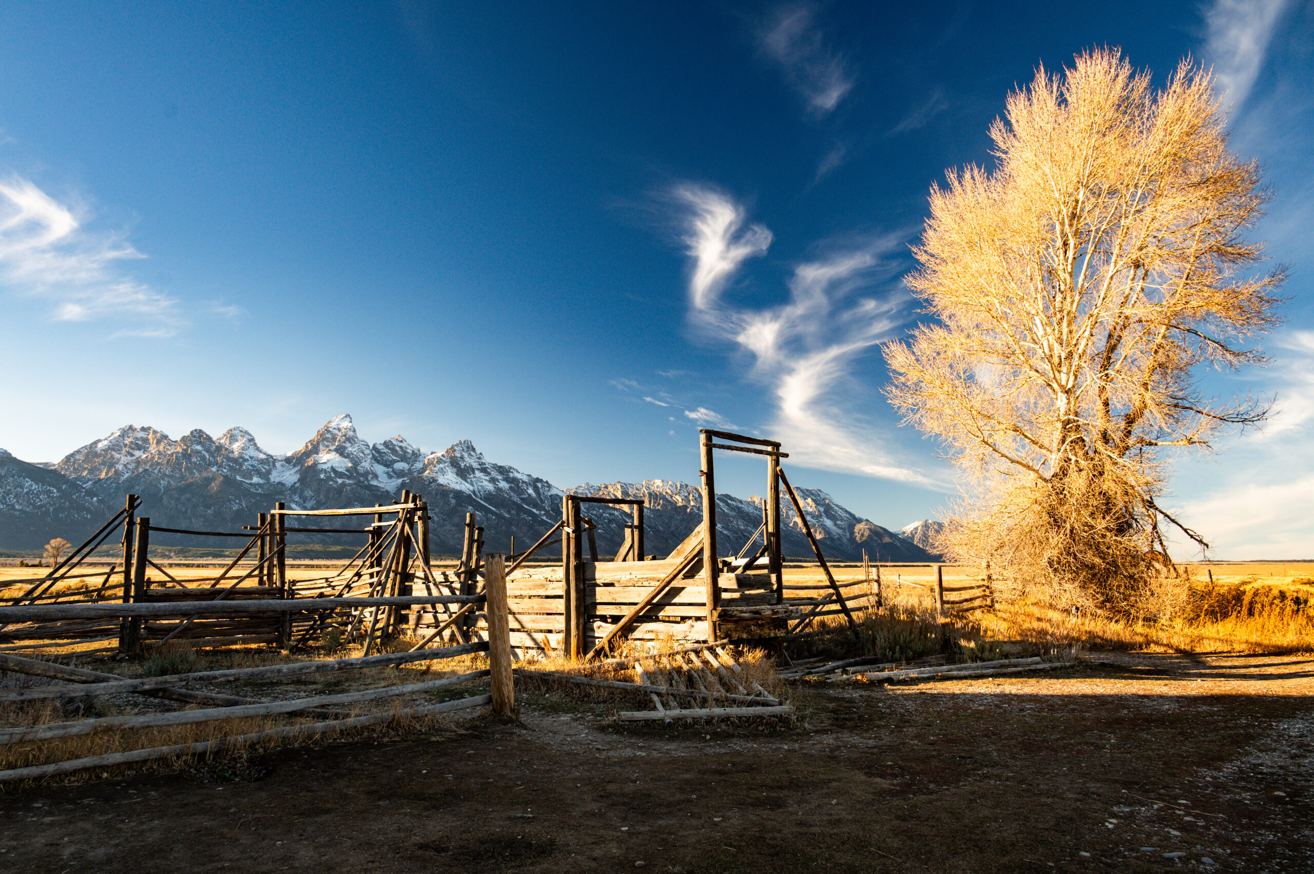
Nach Stopps am Jackson Lake Outlook und der Colter Bay Marina folgen wir der Grand Teton Parkroad. Sehr schön Jenny Lake mit Blick auf den gegenüberliegenden Cascade Cańon. Wir passieren Snake River und die klar abgestuften Geländeterrassen mit dem „National Elk Refuge“, ein Migrationskorridor für verschiedene Antilopenarten (Elk, Pronghorn und Mule Deer). Snake River Overlook und die Mormon Row mit den historischen Farmgebäuden von 1908, u.a. die meist fotografierte Scheune Amerikas. Nachts stehen wir in den Shadow Mountains mit Blick auf die Teton Range.
Durch am Straßenrand parkende Autos werden wir auf einen im Gebüsch liegenden Elchbullen aufmerksam. Vorsichtig pirschen wir näher und entdecken auch die dazugehörige Elchkuh, die neben dem männlichen Tier wiederkauend liegt. Tolle Sichtung und Pirsch. Jackson ist quasi ein nettes Westernstädtchen mitten im Skigebiet , hoch touristisch, gigantische hochwertige Souvenirläden und- Galerien. Weiterfahrt über den Tetonpass (2575m) in einen neuen Bundesstaat: Idaho. Farmen, Bewässerungsanlagen und Windräder. Am Snake River Overlook der größte Cottonwood Galeriewald Nordamerikas (Pappeln), Habitat für Adler und Habichte. In Idaho Falls besichtigen wir den wenig tiefen, aber umso längeren namensgebenden Wasserfall, der zur Stromgewinnung genutzt wird. Abends spiegelt sich der voll beleuchtete Mormonentempel im gestauten Wasser.
Auf dem Weg in den nächsten Bundesstaat Utah kommen wir durchs Shoshonenland und besuchen bei Indian Rocks die Petroglyphen. Die erkalteten Lavafelder des „Craters of the Moon“-Parks haben uns sehr gereizt. Sie fallen aber dem plötzlich Termindruck zum Opfer – wir haben Flüge in die Heimat auf Ende November gebucht und wollen Weihnachten im Kreise der Familie zu Hause feiern.
Salt Lake City zieht uns in seinen Bann. Das „Capitol of Utah“ lädt zur entspannenden Besichtigung ein. Wir schauen uns die Sitzungssäle und das Office des Gouverneurs an, ein wahrlich offenes Haus. Der Bienenkorb (Beehive) ist zentrales Symbol für Utah, das für Fleiß und harte Arbeit („Industry“, das offizielle Staatsmotto) steht und an die mormonischen Pioniere erinnert, die Utah besiedelten; er findet sich auf dem Staatsiegel, der Flagge und als Spitzname „The Beehive State“. Er symbolisiert die Gemeinschaftsarbeit und den Aufbau einer blühenden Wirtschaft, die aus den frühen Siedlern erwuchs, und wird sowohl religiös als auch weltlich genutzt. Das Zentrum ein unglaubliches Konglomerat mächtiger mormonischer Gebäude beeindruckt uns sehr. Wir übernachten in der Nähe des „Natural History Museum“. Am nächsten Morgen finden wir uns in Mitte zahlreicher Schulklassen in diesem interessanten Gebäude mit schöner Ausstellung wieder, lohnenswert. Im Gegensatz dazu die quasi nicht existierende Chinatown, eher nur eine asiatische Mall. Der Antelope Island Park mit der größten Bisonherde Utahs ist unser Standort für die Nacht. Supermond und schöne Ausblicke auf die Wasateh Mountains und die Skylines von SLC.
Am nächsten Tag geht es zum Teil auf einem 12 spurigen Hwy (6+6) über 110km durch das riesige Siedlungskonklomerat SLC und seine Suburbs. Nach einem Bergpass (2277m) und einer canyonartigen Schlucht mit Fluß und Bahnstrecke wird es schnell zunehmend wüstenhafter. Der Arches NP wartet mit einer Hochebene und tollen Felsformationen. Der Campground ist fast voll, wir ergattern den vorletzten Platz. „Zweizellers“ sind noch da, später sitzen wir mit Robert und Jeanette dann noch am Feuer. Morgens dann Wanderungen zum Tapestrew, Broken Arch und im Devils Garden sowie Richtung Parkausgang verschiedene Stopps, v.a. am Delicate Arch, ein Symbol Utahs. Wir folgen dem Colorado und der Potash Rd (Petroglyphen, Dino Spuren und Felskletterer). Danach der Straße Richtung Canyonlands NP bis zum freien Campground Love Mesa. Schöner Blick, Zweizellers kommen später auch noch dazu.
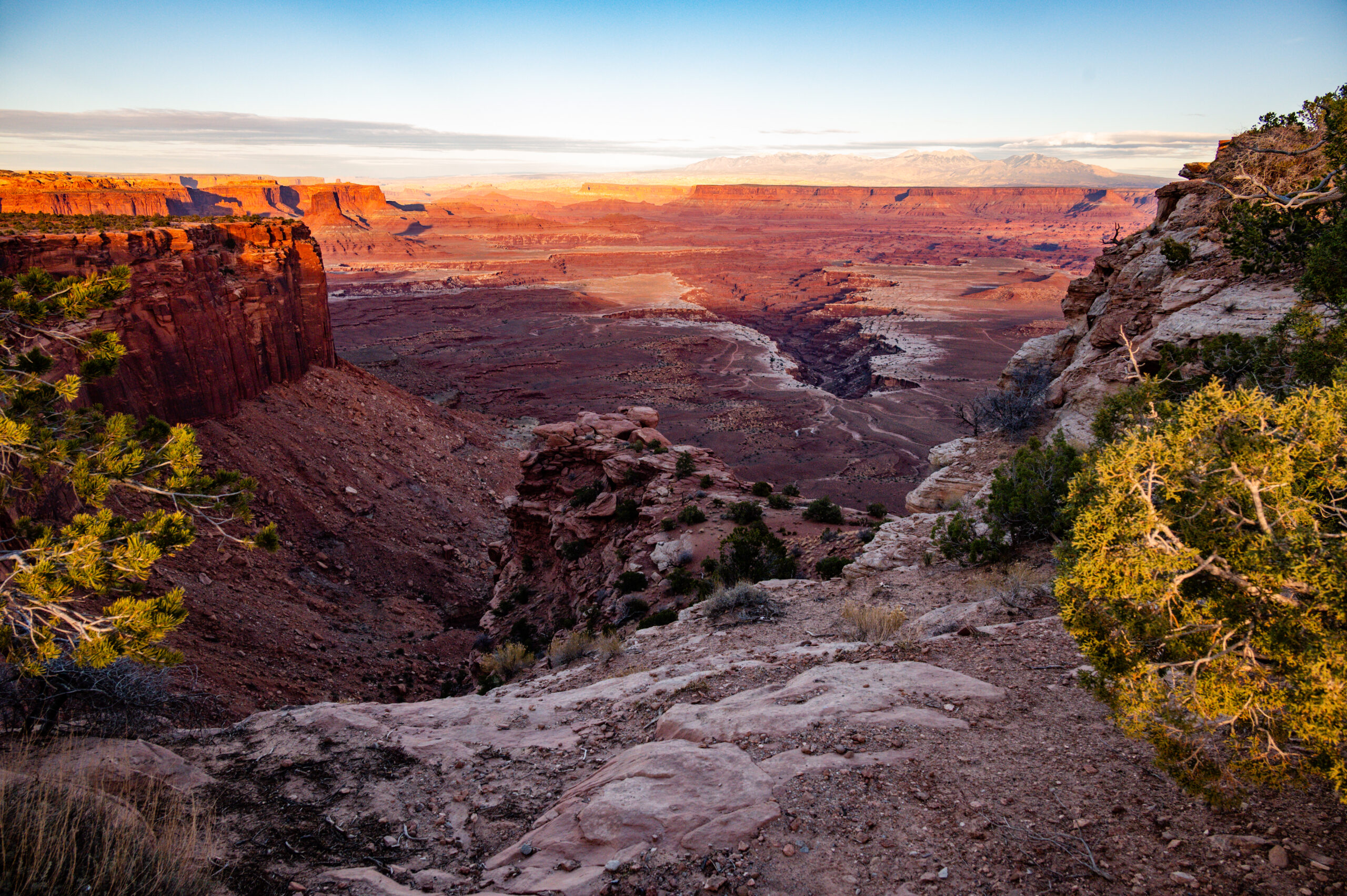
Den ganzen Tag verbringen wir im Canyonlands NP, man fährt quasi auf einer Landbrücke zwischen 2 großen Canyontälern. Die Offroadpiste 100 Meilen White Rim lockt und wir widerstehen (Alaska läßt grüßen). Zu Fuß erkunden wir verschiedene Outlooks, Der Geruch von Wacholder liegt in der Luft, knorrig verschlungene Gehölze, tolles Panorama und immer wieder super schöne Ausblicke. Ein beeindruckender, sehr schöner Tag.
Der Halt in Green River zum Einkaufen wird ungeplant für Gabi zum Frisörbesuch, so unscheinbar und eher heruntergekommen der Laden, so handwerklich perfekt und bezahlbar der Schnitt. Goblin Valley mit seinen Felsformationen ist seinen Abstecher wert. Die Hoodoos faszinieren immer wieder.
Gesteinsformationen in blassorangen bis braunroten Tönen, Sanddünen und Badlands. Dann in der Schlucht von Capital Reef massive senkrechte Kalksteinwände, viele Espen mit leuchten gelben Blättern, liebevoll gepflegte Obstgärten, ehemals von den Mormonen angelegt entlang des fruchtbaren Tales des Fremont Rivers. Hickmann Bridge Trail, Senic Drive und wieder Petroglyphen. Morgens laufen wir noch den Grand Wash Canyon Trail. Der Capitol Reef NP überrascht und begeistert uns vollkommen. Ebenso der Senic Byway HW 12, der uns ausgesprochen gut gefällt, tw. spektakuläre Streckenführung. Boulder, Escalante Petrified Forest. Überall amerikanische Flaggen, es ist Veteransday. Faszinierend der Besuch des State Park, sehr schöner Trail mit vielen Kakteen und Pflanzen (u.a. Buffalo Berry). Im hinteren Abschnitt ist der Weg quasi gepflastert mit größeren und kleinen versteinerten Baumstammfragmenten. Wir bewegen uns auf um die 2200 Höhenmeter durch den Dixie Forest. Der Powell View Point mit weitem Badlandsgebiet. Hier ist auch die größte Fundzahl kreidezeitlicher Dinosaurier. Immer wieder ist der Canaan Peak zu sehen mit seiner hoch aufragenden weiß rosa Abbruchspitze. Wir kommen an den ersten Erosionskanten des Bryce Canyon vorbei. Tolles Licht und Farben.
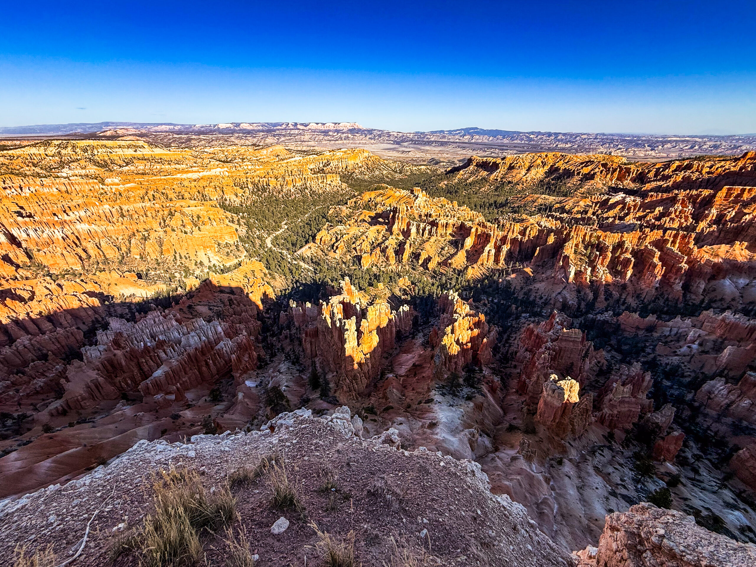
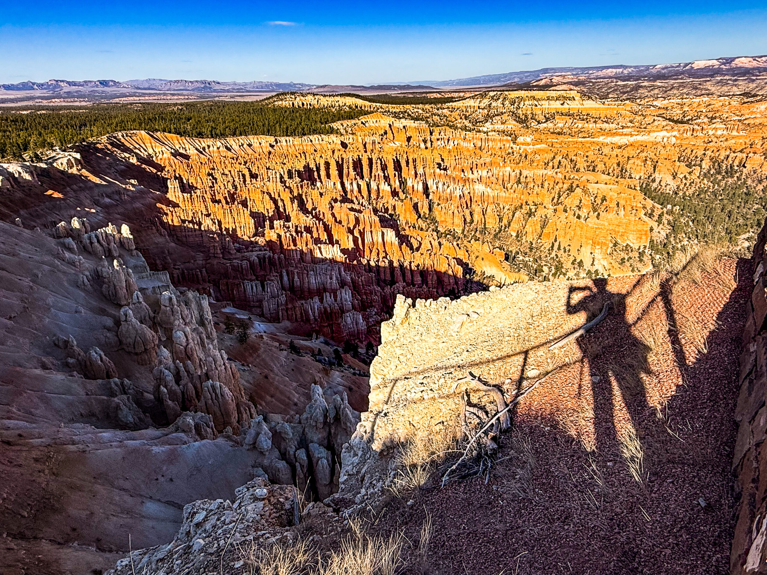
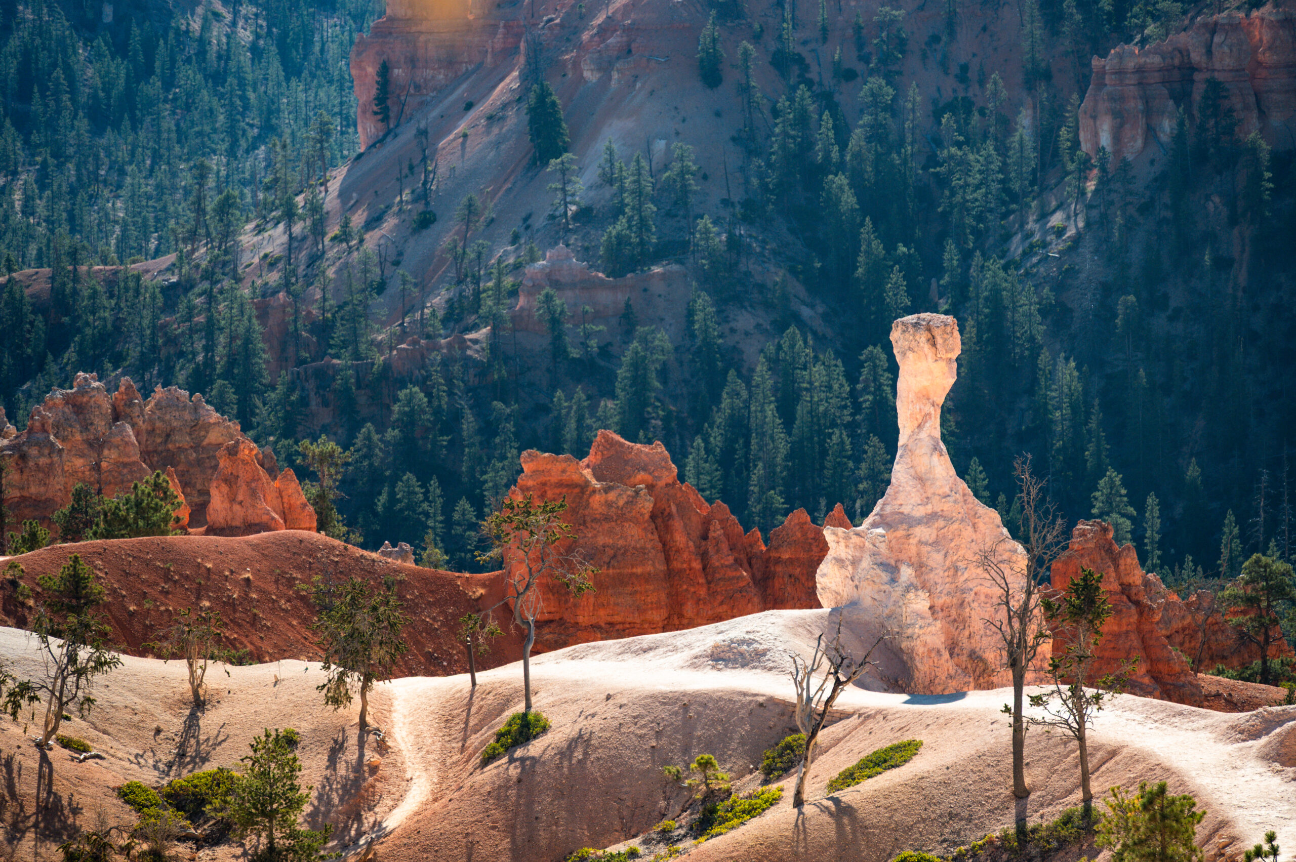
„Bryce Day im Bryce Canyon NP“, Erkundungsfahrt entlang der Parkroad bis auf 2768m. Es ist ungemein beeindruckend, die orange-lachsrote Farbigkeit und die Erosionsformationen fesseln einem. Ebenezer Bryce, der Kirche Jesu Christi der Heiligen der Letzten Tage (=Mormonen) angehörend, baute eine Straße zum Plateau, um Brennholz und Bauholz zu holen. Außerdem errichtete er einen Bewässerungskanal für den Anbau von Feldfrüchten und die Viehhaltung. Die Einheimischen nannten die Schlucht mit den bizarren Felsformationen in der Nähe von Ebenezers Haus „Bryce’s Canyon“ . Die Familie Bryce zog 1880 nach Arizona, der Name blieb jedoch bestehen. Natürlich Pflicht der Sonnenaufgang am Sunrise Point, zugegebenermaßen waren wir nicht die Einzigen. Dies tat dem Schauspiel jedoch keinen Abbruch, einfach schön. Desgleichen die Wanderung vom Rim durch Queens Garden und den Navajo Trail mit Aufstieg durch die „Wallstreet“. Vor lauter Fotostopps kommen wir kaum voran. „America the Beautiful“ im wahrsten Sinne des Wortes. Nach Ende des „shutdown“ können wir am nächsten Morgen auch die NP-Jahreskarte wieder kaufen (80$). Die Fahrt führt durch den Red Canyon und durch das Tal des East Fork Virgin River bis kurz vors Zion NP East Gate.
Gut dass wir 2025 die Strecke fahren, wir brauchen zwar einen Oversized Zuschlag für den Tunnel, ab 2026 wird es nicht mehr erlaubt sein. Der Canyon Overlook Trail direkt vor der Tunneleinfahrt ist wieder ein Augenschmaus, etwas wild aber dennoch einfach zu laufen. Anschließend fahren wir durch den Tunnel und die Serpentinen hinab zum jahreszeitlich einzigen offenen Campground und starten mit dem obligatorischen Shuttle-Bus direkt in den Zion Canyon. Wir laufen den Riverside-Trail bis zu der Stelle, wo es nur noch durch das Wasser weitergeht, was entsprechend Ausrüstung bedingt, die wir uns nicht besorgt haben. Auf Empfehlung der Shuttle-Bus-Fahrerin laufen wir noch zwischen verschiedenen Haltestellen einen netten Pfad am Flußbett des unscheinbaren Virgin Rivers, der jedoch diese gewaltige Schlucht geschaffen hat.
Plötzlich sind wir in grandioser Umgebung allein unterwegs. Sehr guter Tipp!
Nachts im Regen stellen wir fest, dass der Rahmen des Dachfensters undicht ist, nach vorsichtigem Anziehen der lockeren Schrauben ist gottlob alles wieder dicht. Die Zion Vinery über Harvest Host ist das Ziel für die Nacht. Lustige Weinprobe im Mormonenland.
Silver Reef gibt uns Einblick in die Bergbauaktivitäten dieser Region. Ungewöhnlich Silber in Sandstein zu finden. Das alte Silberschürferstädtchen ist quasi heute eine Geisterstadt, das Museum im ehemaligen Wells Fargo Handelsposten lebt von seinen Volontären, die Wissen lebendig vermitteln. Spätabends durchqueren wir Las Vegas und den Strip. Ziel der Aktion ein Treffen mit Ingrid und Jürgen am Lake Mead. Wir bleiben dann doch etwas oberhalb stehen und schenken uns die Piste zum See angesichts des vorhergesagten Regens.
Wider der Prognose nachts kein Regen vormittags sogar richtig schöne Sonne. Lukes kommen gegen 11:00 Uhr von unten hoch, kurzer Talk, dann trennen sich 2025 unsere Wege. Wir drehen in Memoriam eine Runde über den Hover Damm, passieren in Security Check und fahren zum Lake Mead View Point. Erschreckend niedriger Wasserstand.
An allen Tankstellen, Nevadas finden sich Spielautomaten. Wir fahren nach Kalifornien in den Joshua Tree Park. Wüste, Berge, Kakteen, sonst nur ein großes Nichts. Bei Arrowhead Junction kreuzen riesige Züge die Straße. Überall finden sich nun nach dem Regen überflutete Straßensenken.
Allmählich merken wir die veränderten Zeiten, die Sonne geht nun circa 1 Stunde früher auf, dafür wird es abends deutlich früher dunkel. Am Split Rock machen wir eine kleine Wanderung. Viele bizarre, gerundete Felsformation, jedoch kaum Joshua Trees. Cholla Cactus Garden, später noch ein großes Areal mit Ocotillo Kakteen. Kurzer Abstecher nach Palm Springs, wo wir einen alten Schulfreund mit seiner Frau treffen. Vielen Dank, Peter und Sabine für eure Gastfreundschaft.
Besuch des Aqua Caliente Cultural Center.
Zurück im Joshua Tree Park im Jumbo Rocks Campground ist es regnerisch. Morgens treffen wir Cord und Anke mit ihren Kindern. Sie machen Sabbatical, mit der Schule ist abgeklärt, dass das ältere Kind die erste Klasse mit Homeschooling bewältigt. Wir wandern im Hidden Valley an zwischen Felsen eingeschlossenes kleines Tal, viele Sträucher, Kakteenbäume und verschiedenste Felsformationen. Auf der Rückfahrt noch kurz am Skull Rock vorbei gewandert. auf der Fahrt nach Los Angeles, erstmals in den USA ein Stopp bei Aldi wir uns mit Lebkuchen und Christstollen ein. Lecker, ganz wie zu Hause. Via Highway 10 – quer durch Santa Monika – kommen wir urplötzlich an den Pacific Coast Highway. Leider überall no Overnight Schilder. Dafür dann auf dem Campground das Schild: Mountain, Lion Activity.
Am nächsten Morgen treffen wir uns mit Gay und Mark in West Lake Village. Wir hätten es nicht besser treffen können. In aller Ruhe können wir unser Auto herrichten und unsere Koffer packen für den Trip nach Hause. Wir kennen die beiden von unserer Afghanistanreise 1978 und den Folgetreffen. Sie haben sogar eine überdachte Unterkunft für unseren Homey. Ganz lieben Dank für alles, ihr seid unübertroffen. Über Weihnachten werden wir nun zu Hause sein und im Januar unsere Reise fortsetzen.
 Our re-entry into the „lower 48“ is completely unproblematic. The monolith of Chief Mountain is very impressive. We head for the NP Campground in St. Mary. The current shutdown makes booking and paying for park entry difficult. In addition, there is a storm and snow warning for Glacier NP East, with gusts of up to 80 miles/h expected. We park in the direction of the wind and decide to wait out the weather. At night, the Homey is shaken around quite a bit. After waiting it out, we drive along Many Glacier Rd. Beautiful mountain panorama, mighty rock massifs. We see mountain goats and shortly afterwards three grizzlies (a mother with two blond cubs). Hike to Red Rock Falls and later to Swiftcurrent Falls. Unfortunately, Going-to-the-Sun Rd. is already closed for the season, but the road that is still passable is very beautiful.
We are drawn to Yellowstone and the south. We pass a Blackfoot viewpoint with metal structures reminiscent of teepees and beautiful views. We drive over 1,833 m to Browing, but unfortunately the Plains Indian Museum is closed due to the shutdown.
We continue through Blackfoot country, meeting up again with the Lewis & Clark Trail and Missile Field – we are close to Great Falls and last year’s route. The Bynum Reservoir Recreation Area offers a perfect place to park for the night, with a beautiful evening atmosphere and a stunning starry sky.
The landscape becomes hillier and more mountainous. We drive through Helena and Bozeman. The Museum of the Rockies displays local dinosaur finds and a current exhibition commemorating the death of Jane Goodall and her life’s work. We stroll through the beautiful Main Street with its brick buildings and a great tea shop, but unfortunately astronomical prices (113g/28$). Later, we receive an email from Rob Sisson, the Kappelrodeck family.
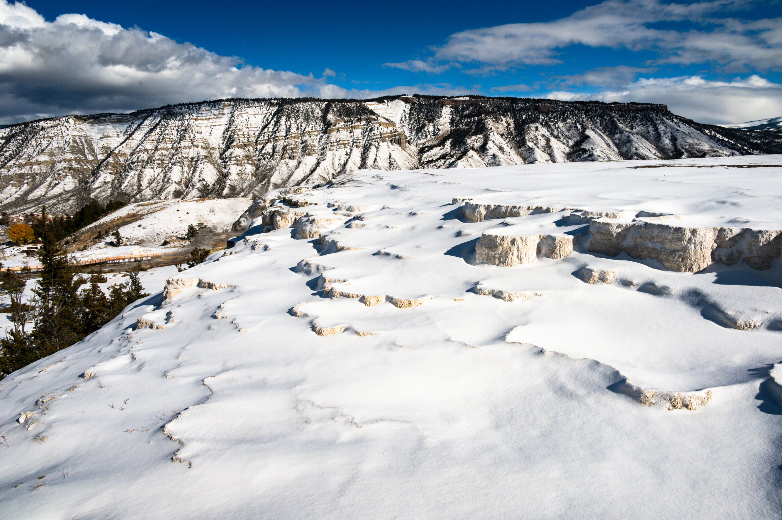
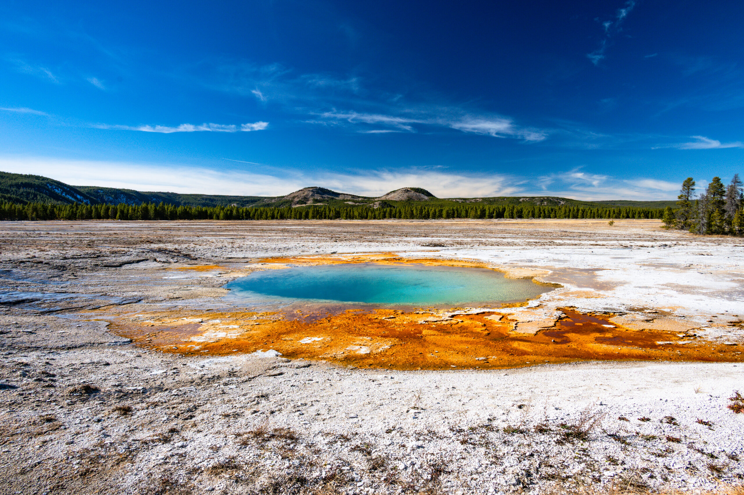
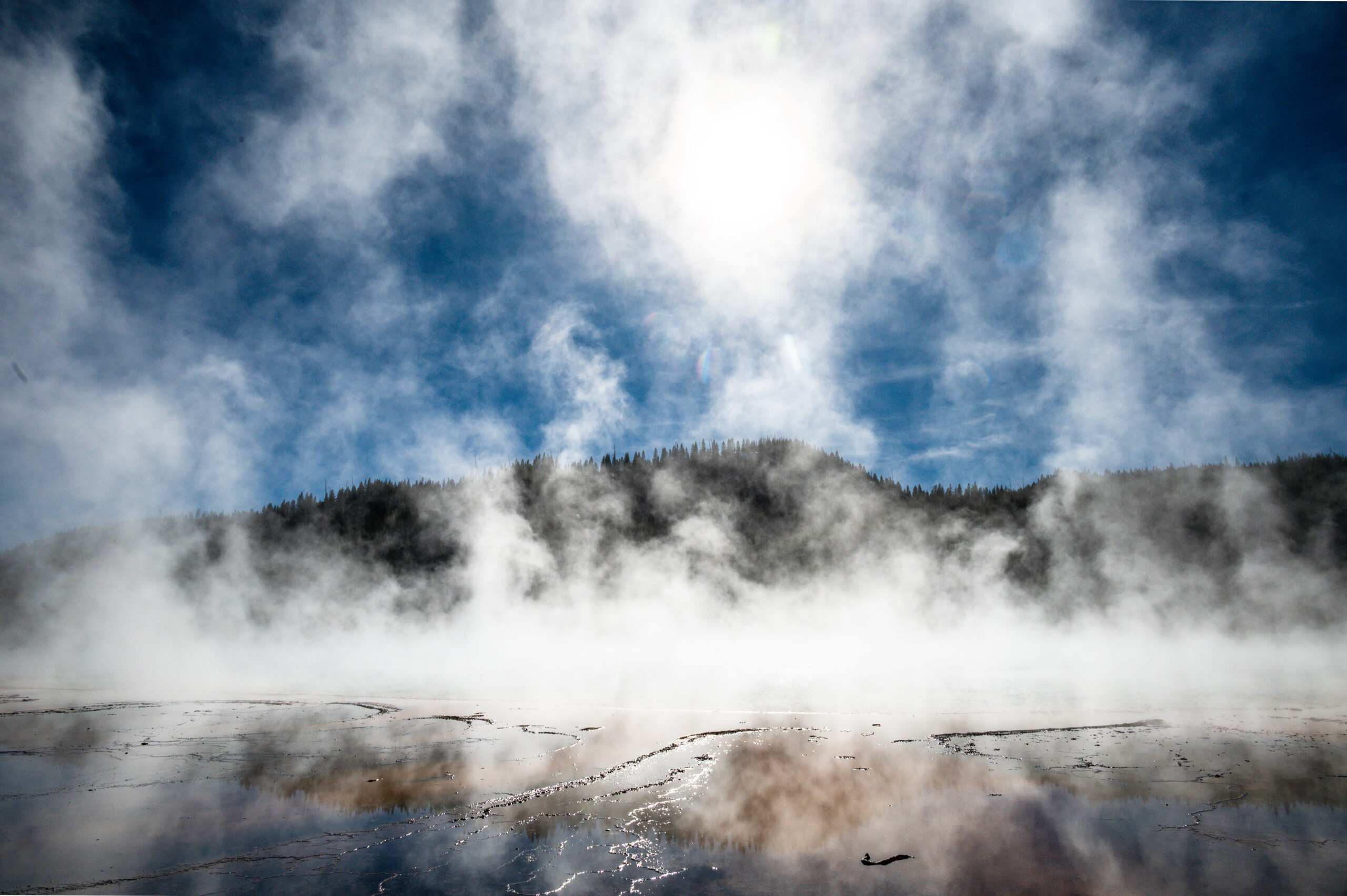
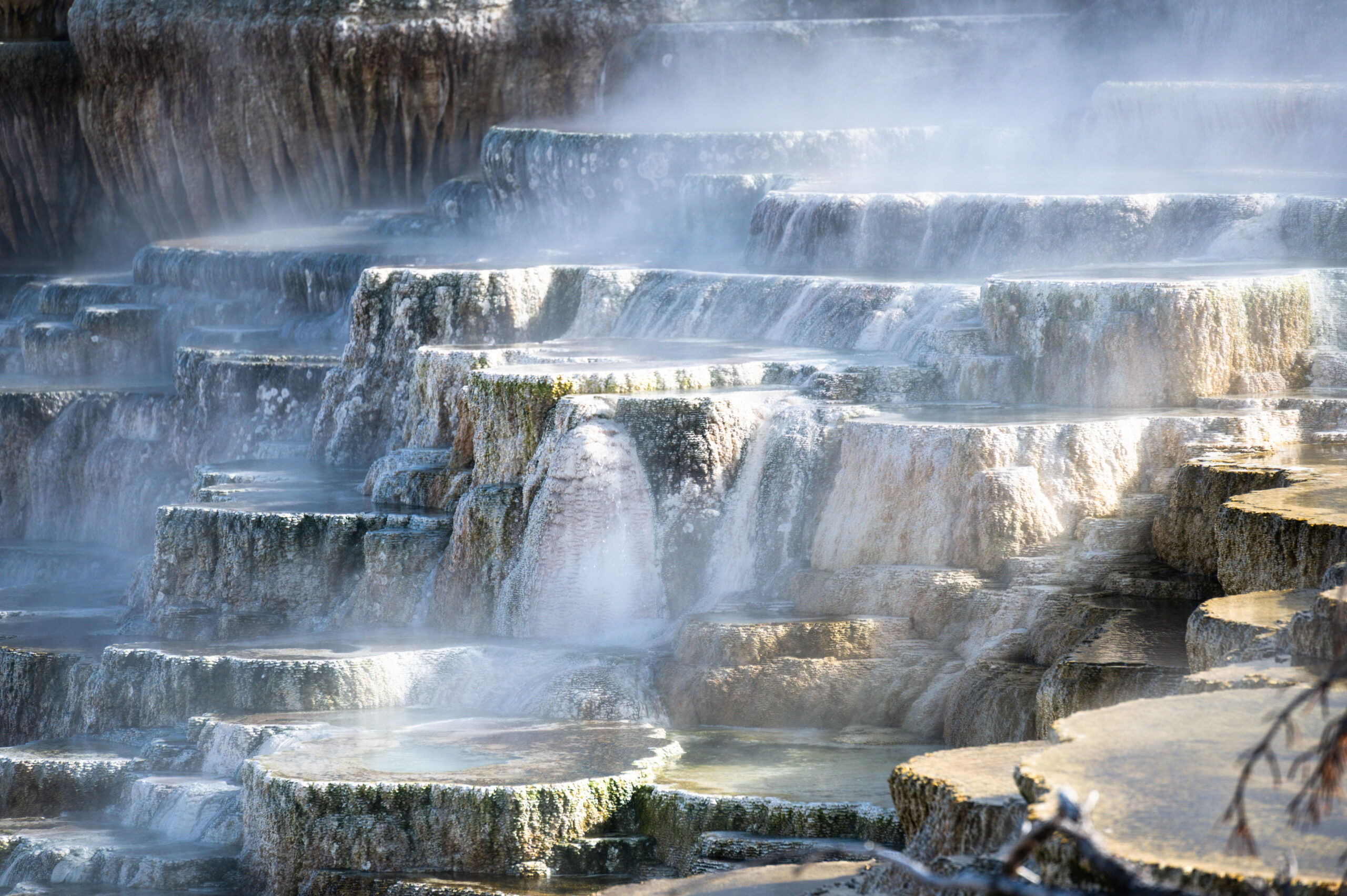
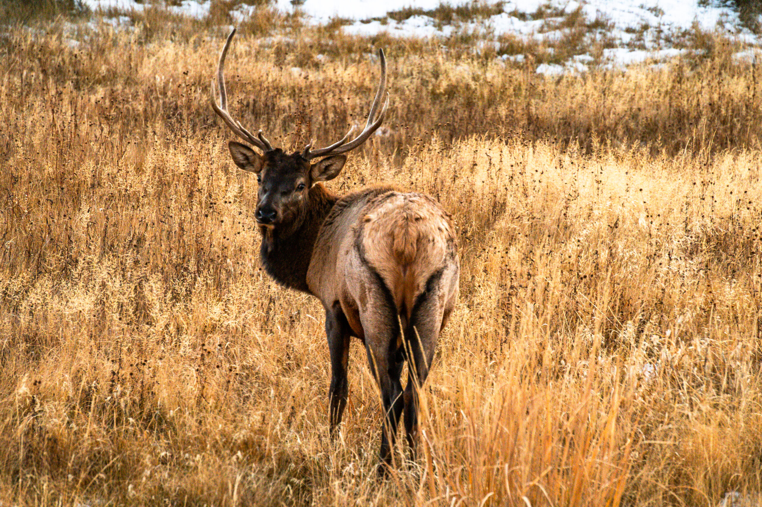
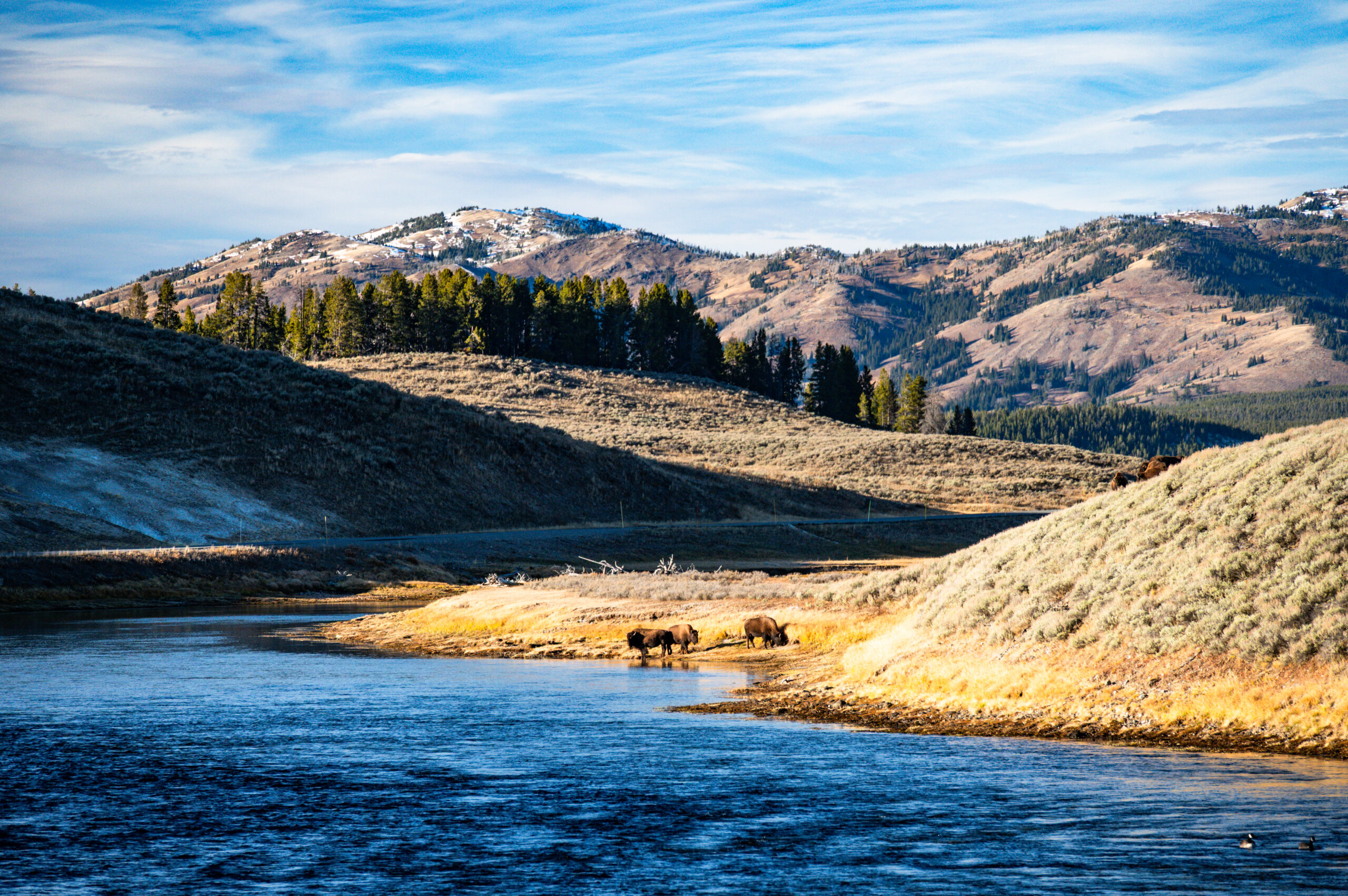
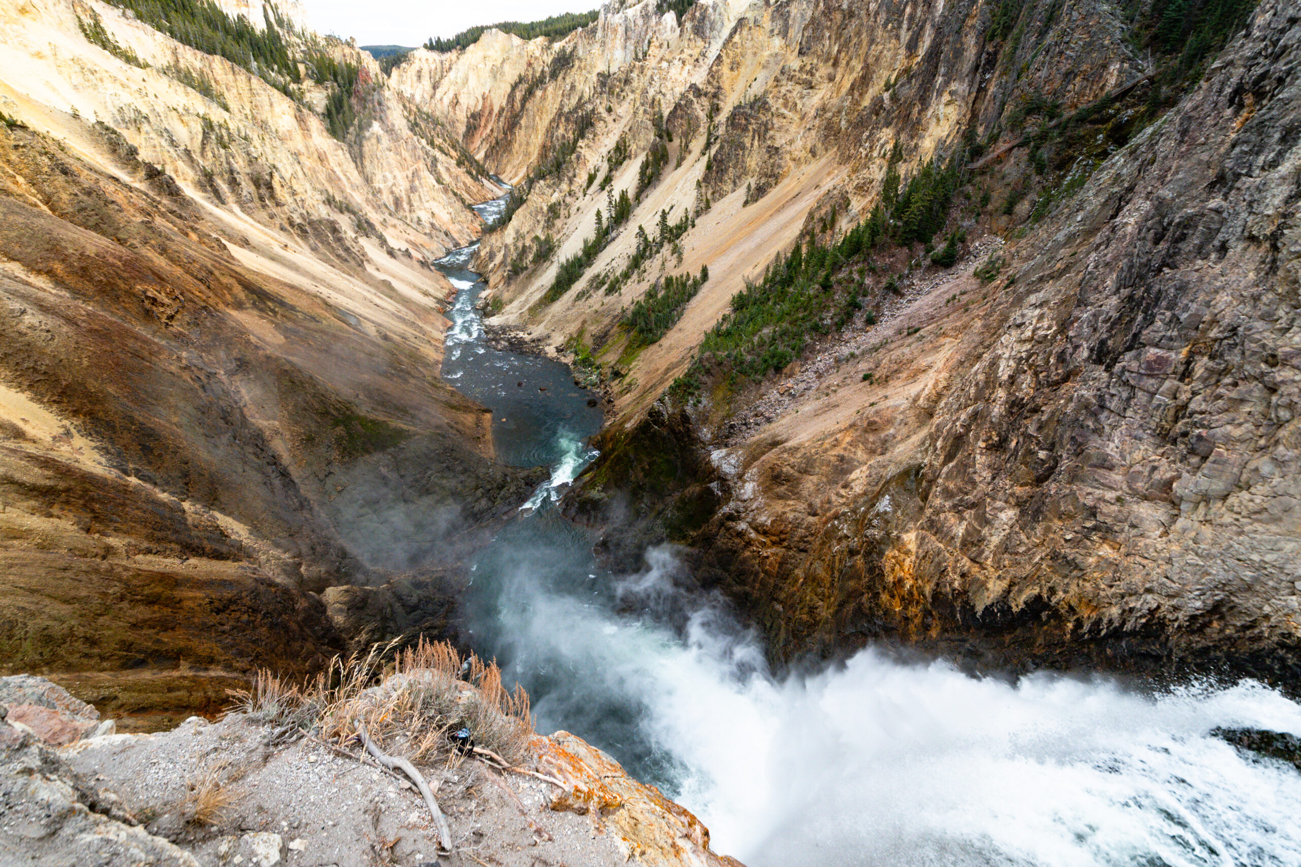
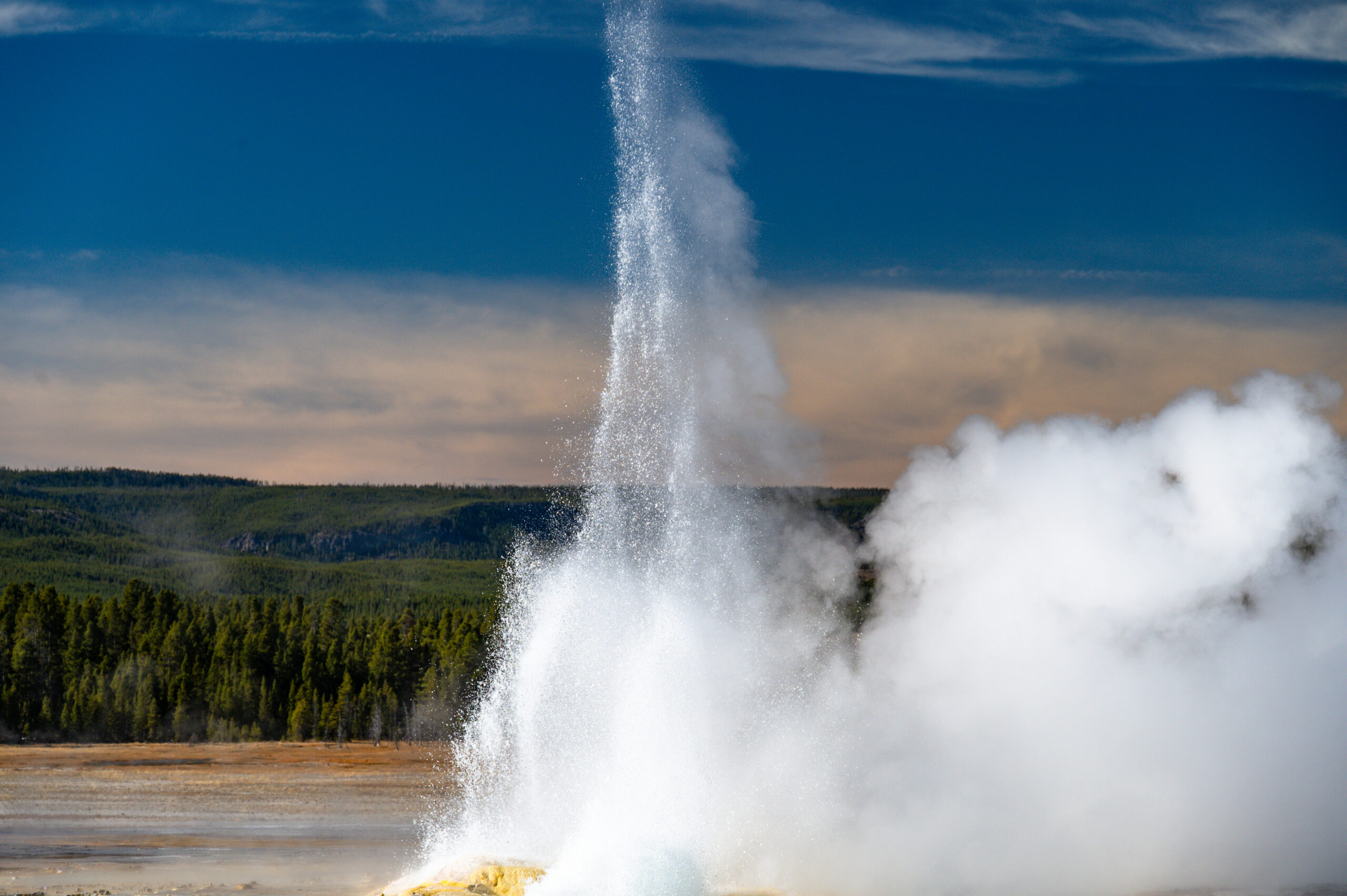
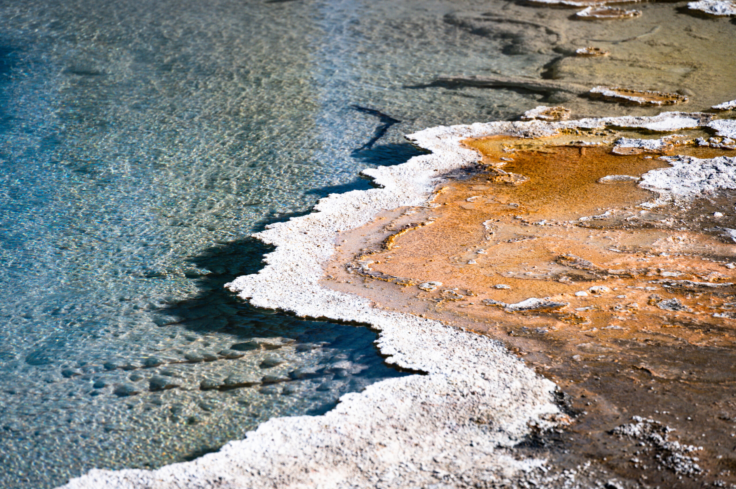
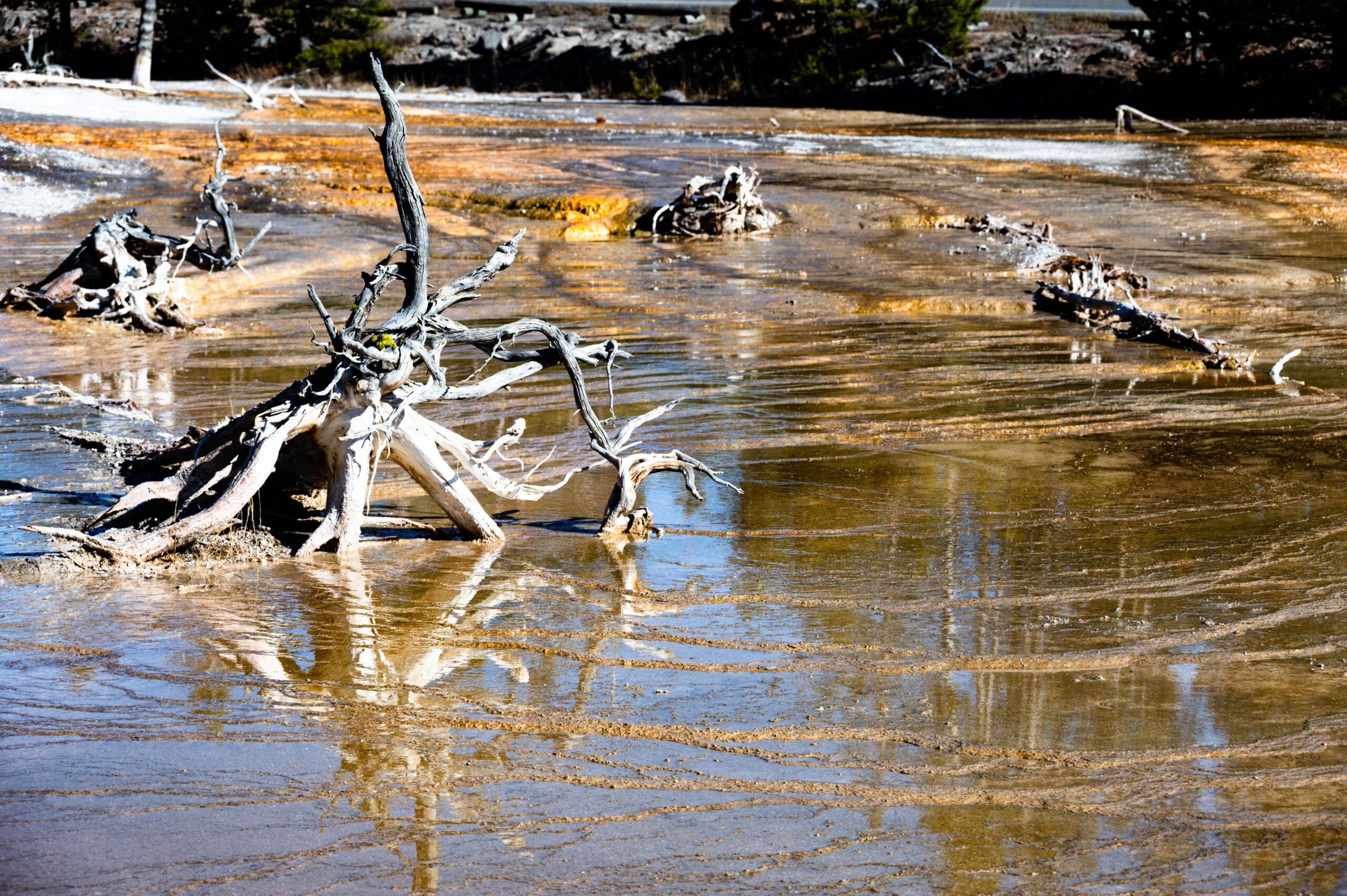
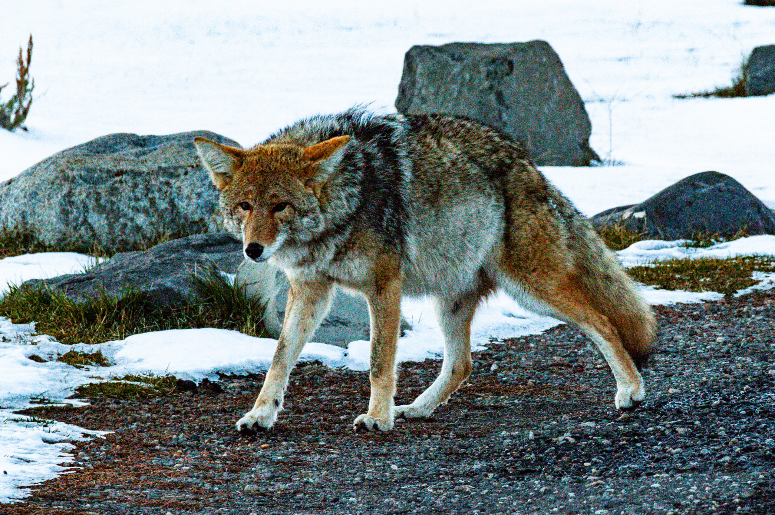
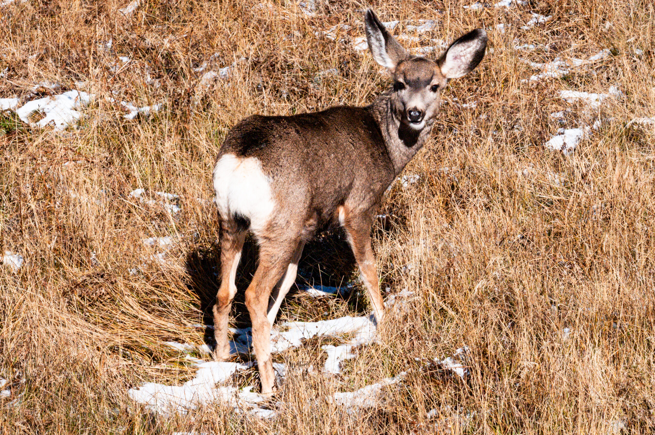
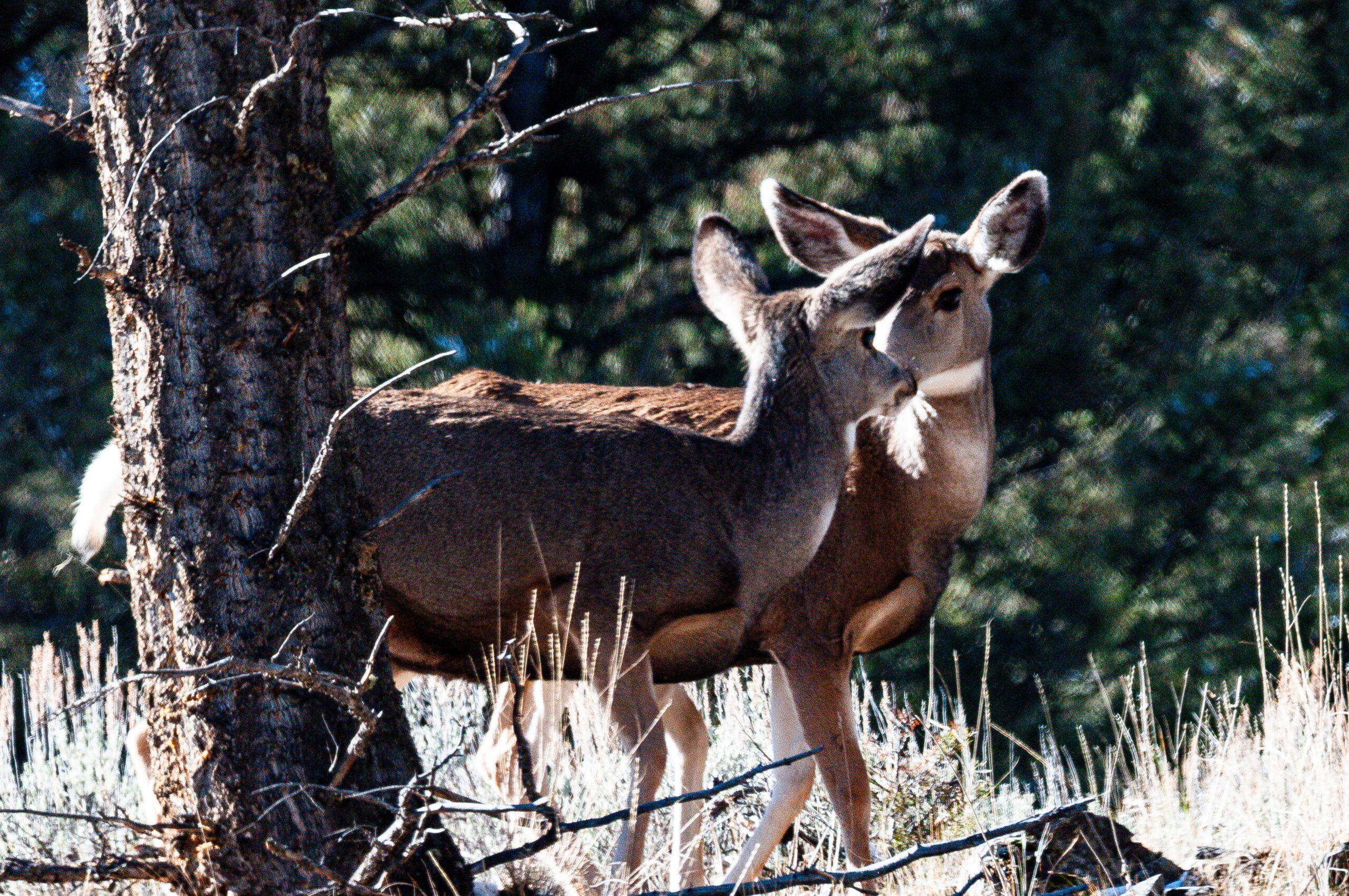
We spend the last week of October in Yellowstone National Park and are absolutely thrilled. Unfortunately, only one campground is still open near Mammoth, a historic garrison that today looks more like a well-kept spa town. We drive and hike through the national park in beautiful weather (cold with clear blue skies). We are surprised by the diverse volcanic activity: it bubbles, hisses, boils, smells of sulfur—spectacular images. At Old Faithful, we miss the eruption by a few minutes, so we turn around and drive back to experience Grand Canyon Artist Point in the evening atmosphere, after crossing the Continental Divide (2,600 m, Homey’s record height so far). In Hayden Valley, bison graze throughout the valley. Now that we have been able to book a permanent spot at the campground, we drive to Dunraven Pass the next day. At 8,859 ft or 2,700 m, it is the highest point on Grand Loop Rd. The pass is named after the English Earl of Dunraven, who undertook an expedition to the Rocky Mountains in 1874, and connects the town of Tower in the north with Canyon Village in the south. Another record altitude for the Homey. We walk various loops on the Grand Canyon North Rim, including to Lower Falls and Red Rock Point. Rhyolite rock is everywhere, but Yellowstone, which gives the park its name, is only found far to the east of Montana on the riverbank. Rising winds and clouds herald the coming blizzard, which we wait out at the campground. Now everything is white and cold (-10 °C) and we explore Lamar Valley. The Donraven Pass road is actually closed due to snow after Towe Falls. We visit the „Petrified Tree“ and see wapiti, moose, black-tailed deer, many bison, coyotes, and black wolves. The latter, however, only through the powerful optics of the „wolf spotters,“ who follow the animals all day with their binoculars. They have set up chairs and tripods for this purpose and willingly explain what can be seen where and how, showing snapshots they have taken with their cell phones using special devices. With the naked eye, all you can see are distant black dots.
The next day, we head back to Lamar Valley to visit the „petrified forest.“ It’s beautiful but also very strenuous, with some steep, muddy, and slippery sections due to the softened ground and snow. We see bear and wolf tracks but none of the animals themselves. Scattered across the slope are several petrified tree trunks—the reward for our efforts. On the way back, we saw the begging coyote from yesterday again, and later a second one.
On the penultimate day the park was open, we drove all the way south, passing the large herd of wapiti today in the sagebrush. Everywhere, steaming geysers, bodies of water, and streams now in a snow-covered landscape. Artist Paintpols, Grand Prismatic Overlook, bison crossing the river in the Fountain Flats, another coyote, even a grizzly bear in the distance. This time, Old Faithful shows what it can really do. We leave the park through the Lewis River Gorge and head towards Grand Teton National Park. A magnificent week lies behind us.
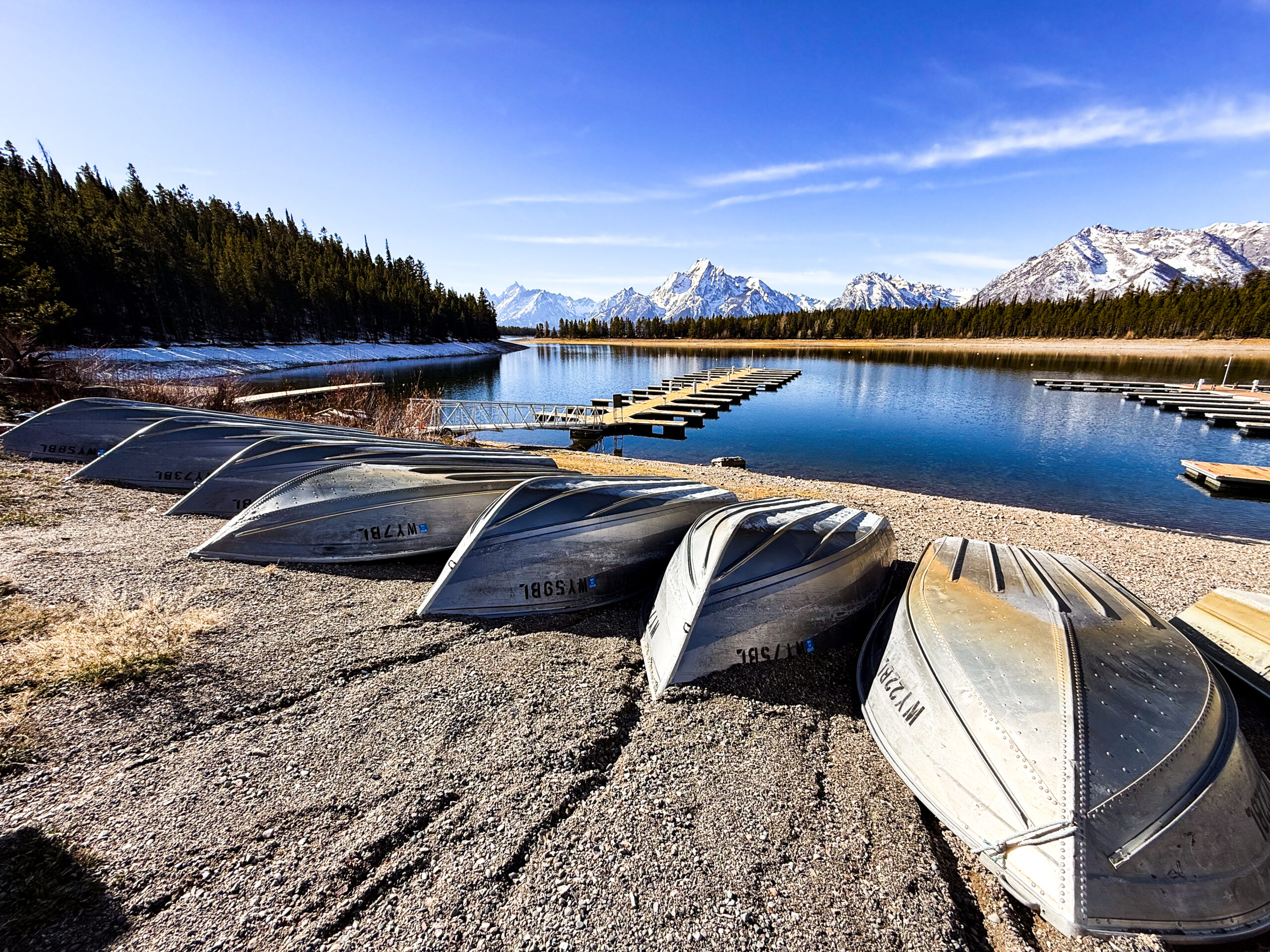
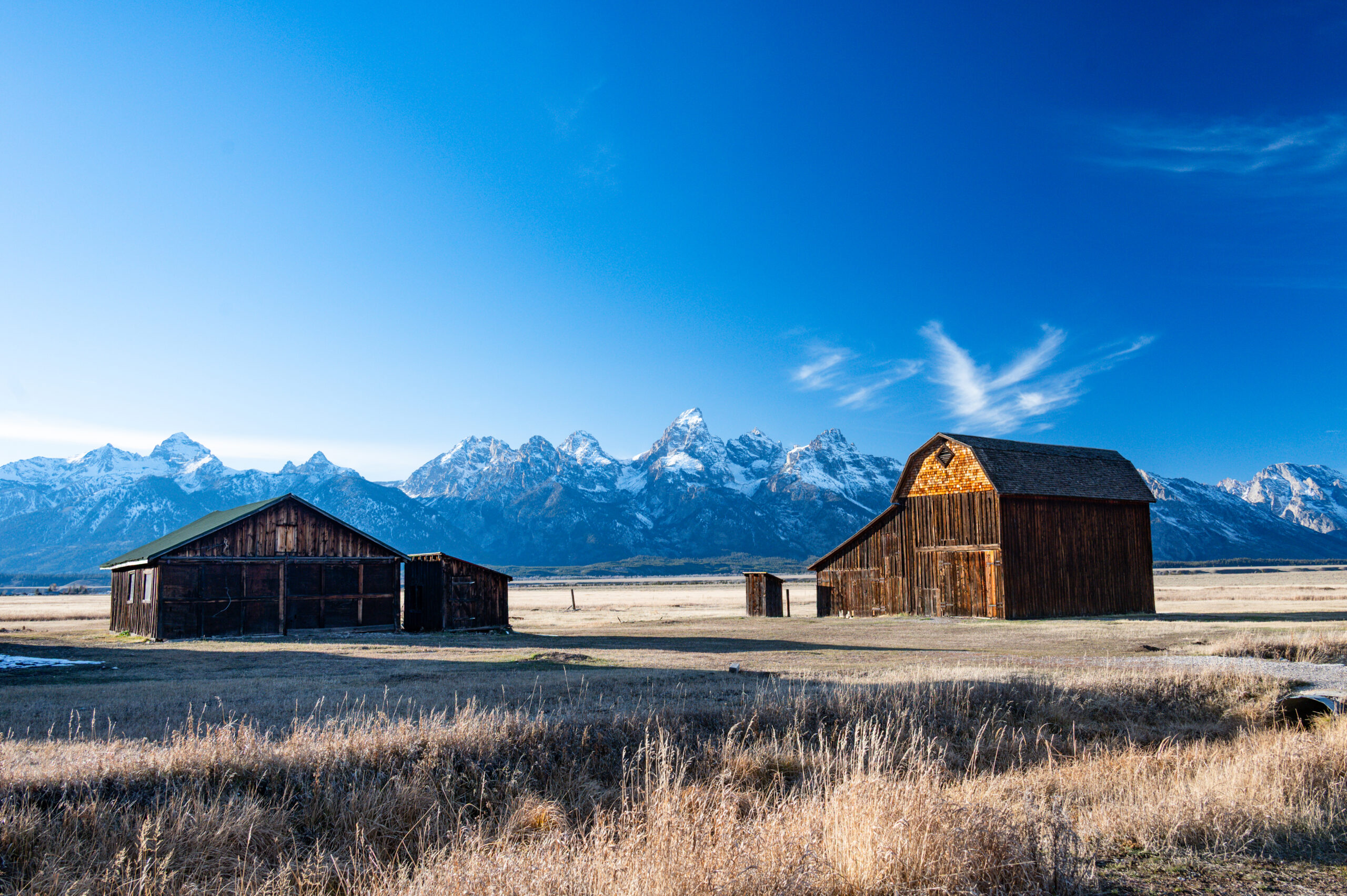
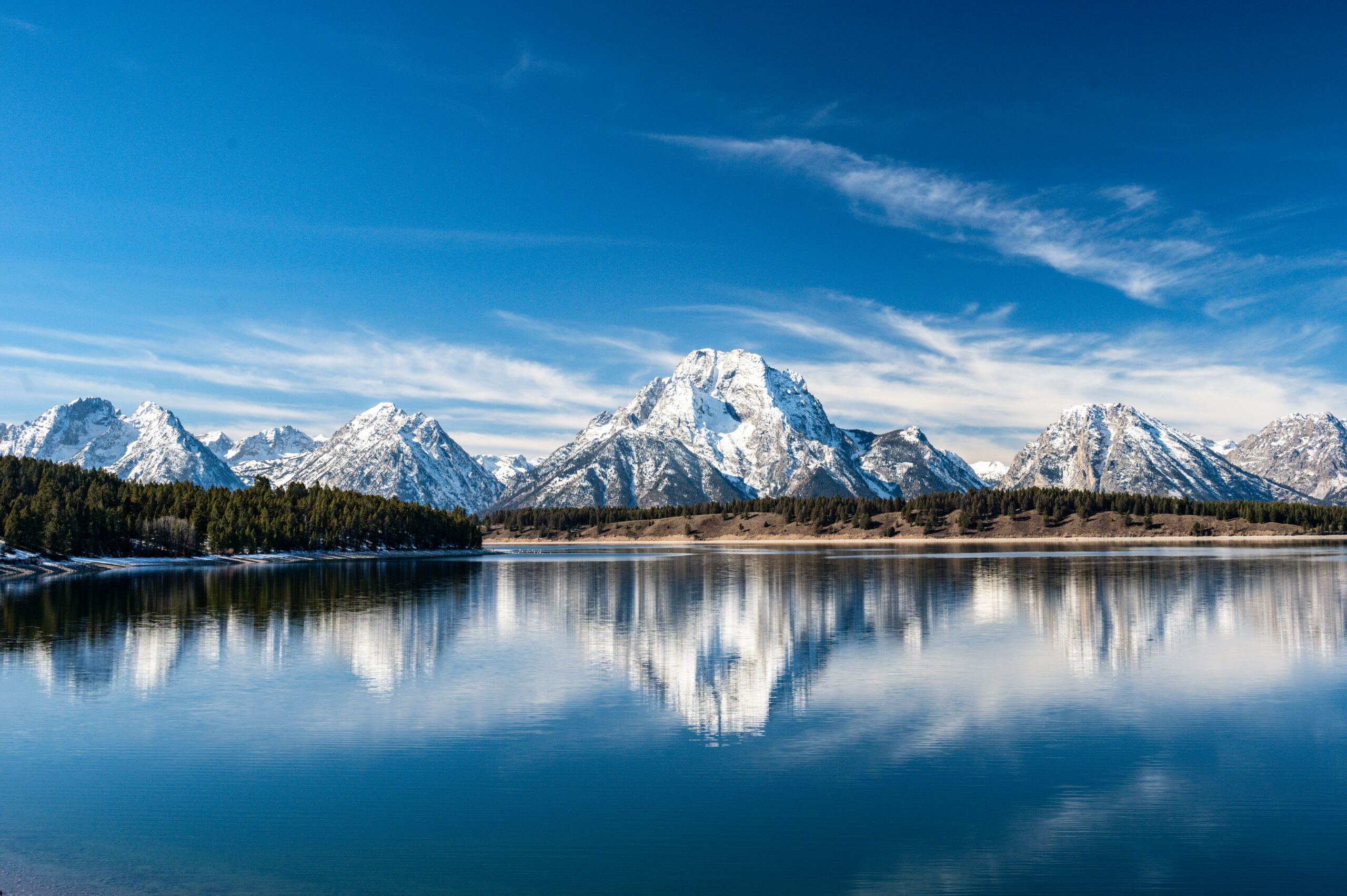
After stops at Jackson Lake Outlook and Colter Bay Marina, we follow Grand Teton Park Road. Jenny Lake is very beautiful, with a view of Cascade Canyon on the opposite side. We pass Snake River and the clearly terraced terrain with the National Elk Refuge, a migration corridor for various antelope species (elk, pronghorn, and mule deer). Snake River Overlook and Mormon Row with its historic farm buildings from 1908, including the most photographed barn in America. At night, we camp in the Shadow Mountains with a view of the Teton Range.
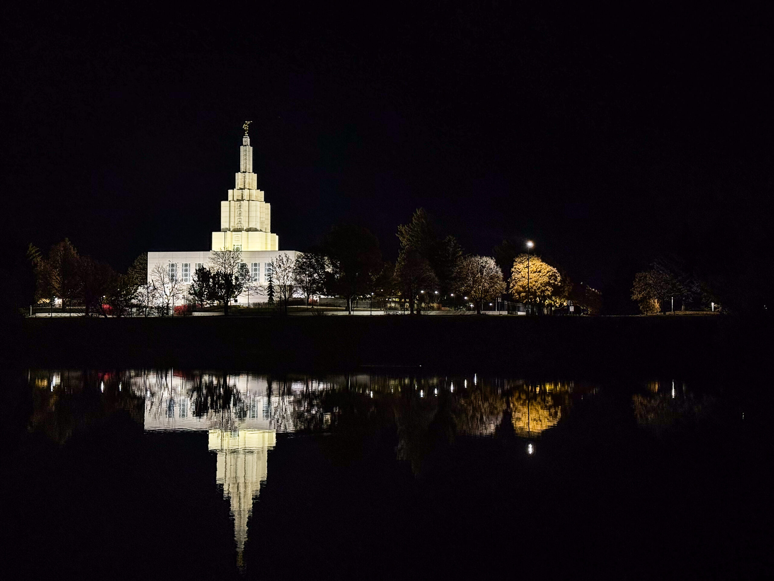
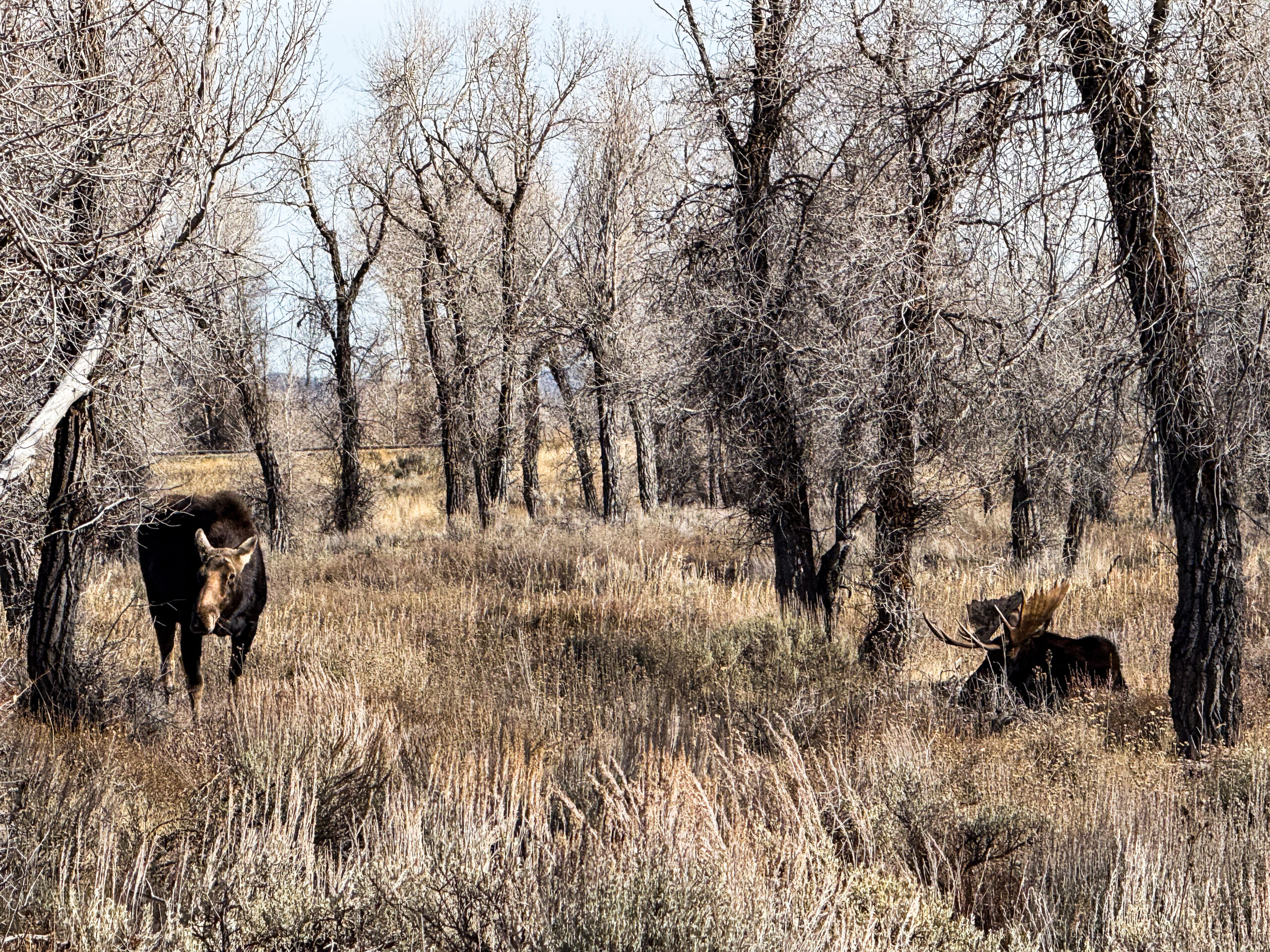
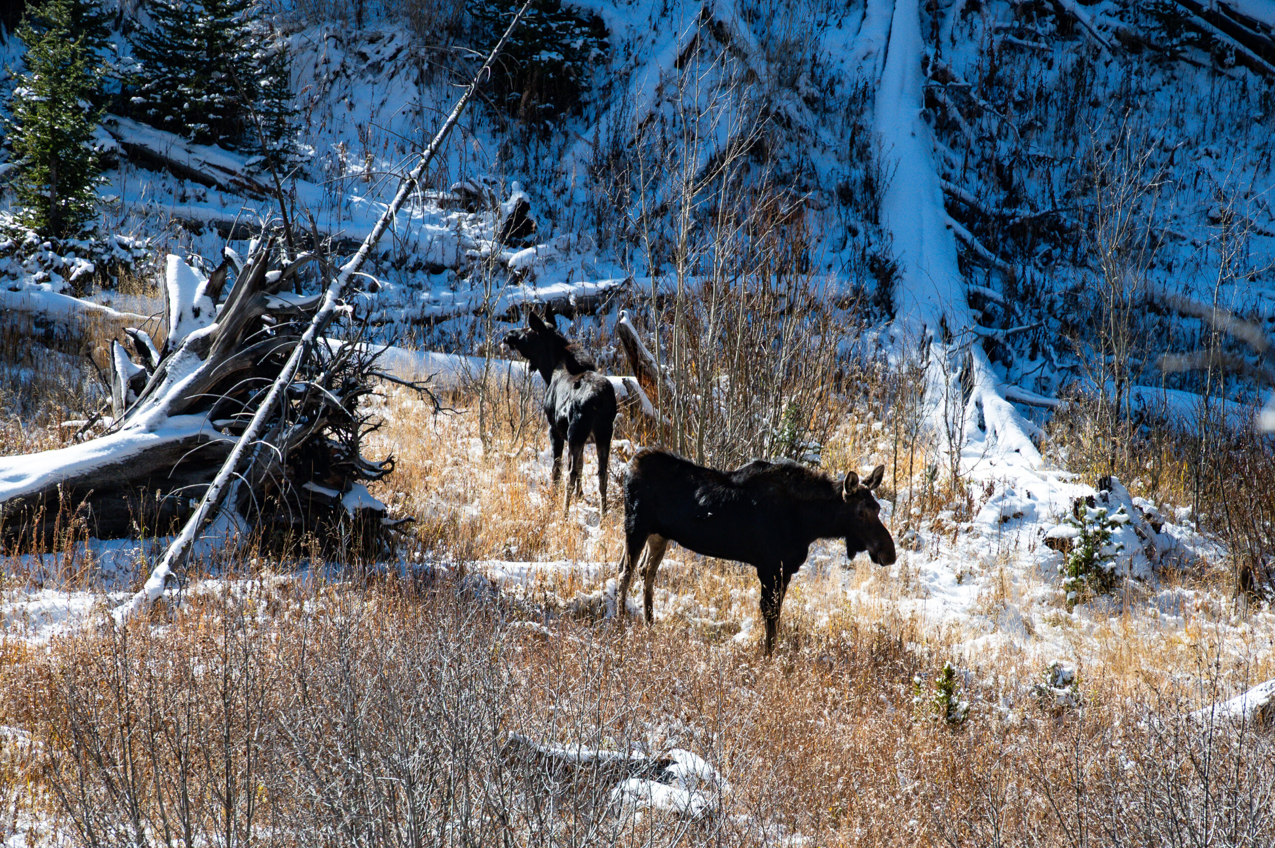
Cars parked at the side of the road alert us to a bull elk lying in the bushes. We carefully stalk closer and discover the female elk lying next to the male, chewing her cud. Great sighting and stalking. Jackson is basically a nice little western town in the middle of a ski resort, highly touristy, with huge, high-quality souvenir shops and galleries. We continue over the Teton Pass (2575 m) into a new state: Idaho. Farms, irrigation systems, and wind turbines. At Snake River Overlook, we see the largest cottonwood gallery forest in North America (poplars), habitat for eagles and hawks. In Idaho Falls, we visit the shallow but long waterfall that gives the city its name, which is used to generate electricity. In the evening, the fully illuminated Mormon temple is reflected in the dammed water.
On the way to the next state, Utah, we pass through Shoshone country and visit the petroglyphs at Indian Rocks. The cooled lava fields of Craters of the Moon National Monument really appeal to us. However, they fall victim to sudden time pressure – we have booked flights home for the end of November and want to celebrate Christmas with our families at home.
Salt Lake City captivates us. The Capitol of Utah invites us to take a relaxing tour. We look at the meeting rooms and the governor’s office, a truly open house. The beehive is the central symbol of Utah, representing diligence and hard work („Industry,“ the official state motto) and commemorating the Mormon pioneers who settled Utah; it appears on the state seal, the flag, and as the nickname „The Beehive State.“ It symbolizes the community work and the development of a thriving economy that grew out of the early settlers and is used for both religious and secular purposes. The center, an incredible conglomerate of mighty Mormon buildings, impresses us greatly. We spend the night near the Natural History Museum. The next morning, we find ourselves surrounded by numerous school classes in this interesting building with its beautiful exhibition, which is well worth a visit. In contrast, Chinatown is virtually non-existent, more like an Asian mall. Antelope Island Park, home to Utah’s largest bison herd, is our location for the night. Supermoon and beautiful views of the Wasateh Mountains and the SLC skyline.
The next day, we drive 110 km through the huge conurbation of SLC and its suburbs, partly on a 12-lane highway (6+6). After a mountain pass (2277 m) and a canyon-like gorge with a river and railway line, the landscape quickly becomes more desert-like. Arches National Park awaits us with a plateau and amazing rock formations. The campground is almost full, but we manage to get the second-to-last spot. The „Zweizellers“ are still there, and later we sit around the fire with Robert and Jeanette. In the morning, we hike to Tapestrew, Broken Arch, and Devils Garden, as well as making various stops on the way to the park exit, especially at Delicate Arch, a symbol of Utah. We follow the Colorado River and Potash Rd (petroglyphs, dinosaur tracks, and rock climbers). Then we take the road towards Canyonlands NP to the free Love Mesa campground. Beautiful view, „Zweizellers“ join us later.
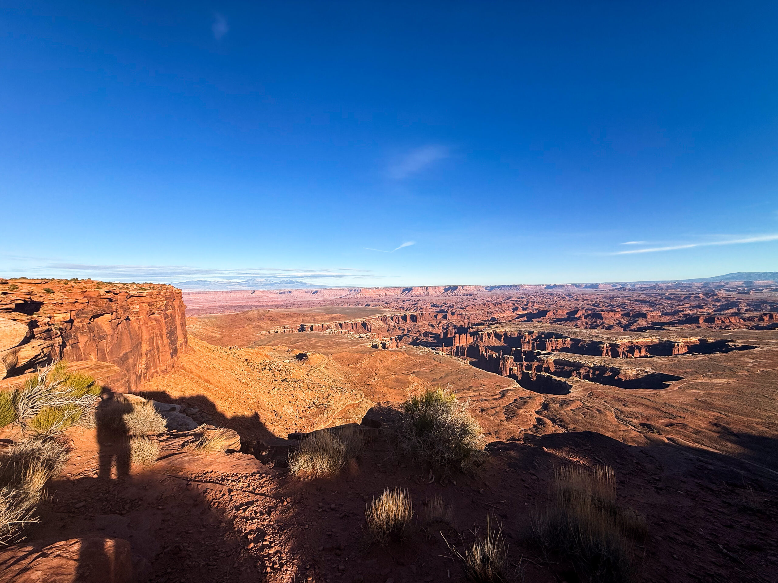
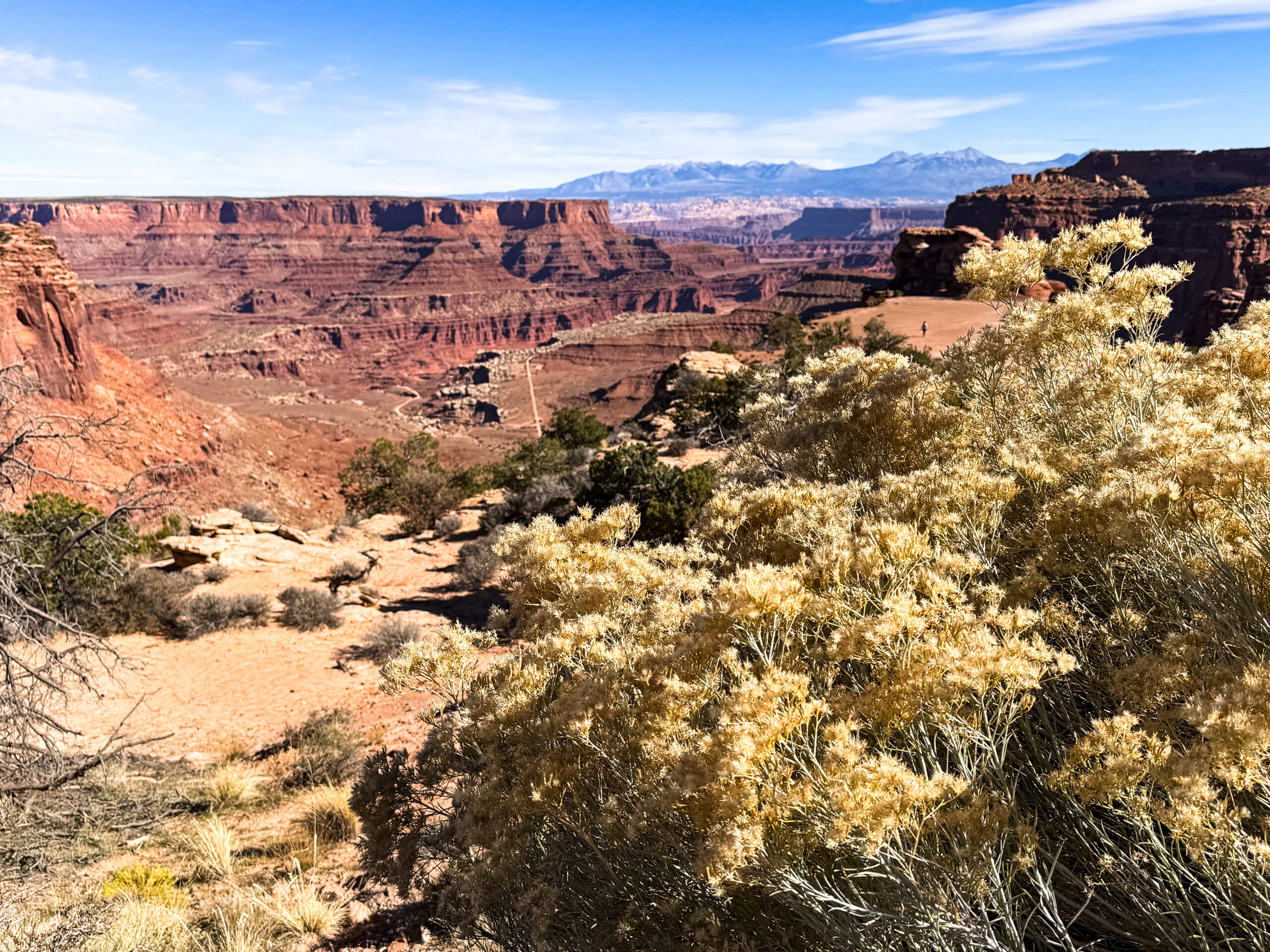
We spend the whole day in Canyonlands NP, driving on a land bridge between two large canyon valleys. The 100-mile White Rim off-road trail beckons, but we resist (Alaska sends its regards). We explore various outlooks on foot. The smell of juniper is in the air, gnarled trees, great panorama and beautiful views again and again. An impressive, very beautiful day.
The stop in Green River for shopping turns into an unplanned visit to the hairdresser for Gabi. As inconspicuous and rather run-down as the shop is, the haircut is perfectly done and affordable. Goblin Valley with its rock formations is worth a detour. The hoodoos never cease to fascinate.
Rock formations in pale orange to brown-red tones, sand dunes, and badlands. Then, in the Capital Reef gorge, massive vertical limestone walls, many aspens with bright yellow leaves, lovingly tended orchards, formerly planted by the Mormons along the fertile valley of the Fremont River. Hickmann Bridge Trail, Scenic Drive, and petroglyphs again. In the morning, we walk the Grand Wash Canyon Trail. Capitol Reef National Park surprises and delights us completely. So does the Scenic Byway HW 12, which we really like, with some spectacular stretches. Boulder, Escalante Petrified Forest. American flags everywhere, it’s Veterans Day. A fascinating visit to the state park, a very beautiful trail with lots of cacti and plants (including buffalo berry). In the rear section, the path is virtually paved with large and small fossilized tree trunk fragments. We are moving at an altitude of around 2200 meters through the Dixie Forest. The Powell View Point with a wide badlands area. This is also where the largest number of Cretaceous dinosaurs have been found. Canaan Peak can be seen again and again with its towering white-pink breakaway peak. We pass the first erosion edges of Bryce Canyon. Great light and colors.
Bryce Day in Bryce Canyon National Park, exploratory trip along the park road up to 2768m. It is incredibly impressive, the orange-salmon red colors and erosion formations are captivating. Ebenezer Bryce, a member of the Church of Jesus Christ of Latter-day Saints (Mormons), built a road to the plateau to fetch firewood and timber. He also constructed an irrigation canal for growing crops and raising livestock. The locals named the canyon with the bizarre rock formations near Ebenezer’s house „Bryce’s Canyon.“ The Bryce family moved to Arizona in 1880, but the name remained. Of course, we had to see the sunrise at Sunrise Point, and admittedly, we weren’t the only ones. However, this did not detract from the spectacle, which was simply beautiful. The same goes for the hike from the rim through Queens Garden and the Navajo Trail with the ascent through „Wall Street.“ We can hardly make any progress because we keep stopping to take photos. „America the Beautiful“ in the truest sense of the word. After the shutdown ends, we can buy the NP annual pass again the next morning ($80). The drive takes us through Red Canyon and the East Fork Virgin River Valley to just before the Zion NP East Gate.
It’s a good thing we’re driving this route in 2025, as we need an oversized surcharge for the tunnel, but from 2026 it will no longer be allowed. The Canyon Overlook Trail just before the tunnel entrance is another feast for the eyes, a little wild but still easy to walk. We then drive through the tunnel and down the switchbacks to the only campground open at this time of year and take the obligatory shuttle bus directly into Zion Canyon. We walk the Riverside Trail to the point where the only way forward is through the water, which requires special equipment that we did not bring with us. On the recommendation of the shuttle bus driver, we walk between different stops along a nice path on the riverbed of the inconspicuous Virgin River, which has created this mighty gorge.
Suddenly, we find ourselves alone in magnificent surroundings. Very good tip!
At night in the rain, we notice that the frame of the skylight is leaking, but after carefully tightening the loose screws, thankfully everything is watertight again. The Zion Vinery via Harvest Host is our destination for the night. A fun wine tasting in Mormon country.
Silver Reef gives us an insight into the mining activities in this region. It is unusual to find silver in sandstone. The old silver mining town is now virtually a ghost town, and the museum in the former Wells Fargo trading post is kept alive by its volunteers, who bring knowledge to life. Late in the evening, we drive through Las Vegas and the Strip. The goal is to meet up with Ingrid and Jürgen at Lake Mead. We decide to stop a little above the lake and skip the drive down to the lake in view of the predicted rain.
Contrary to the forecast, there is no rain at night and even beautiful sunshine in the morning. Lukes arrives from below at around 11:00 a.m., we have a quick chat, then in 2025 our paths separate. In memoriam, we take a drive over the Hoover Dam, pass through security checks, and drive to Lake Mead View Point. The water level is alarmingly low.
There are slot machines at all gas stations in Nevada. We drive to California to Joshua Tree Park. Desert, mountains, cacti, otherwise just a big nothing. At Arrowhead Junction, huge trains cross the road. After the rain, there are now flooded road depressions everywhere.
We gradually notice the changing times; the sun now rises about an hour earlier, but it gets dark much earlier in the evening. We take a short hike at Split Rock. Lots of bizarre, rounded rock formations, but hardly any Joshua trees. Cholla Cactus Garden, later a large area with ocotillo cacti. Short detour to Palm Springs, where we meet an old school friend and his wife. Thank you, Peter and Sabine, for your hospitality.
Visit to the Aqua Caliente Cultural Center.
Back at Joshua Tree Park at Jumbo Rocks Campground, it is rainy. In the morning, we meet Cord and Anke with their children. They are on sabbatical, and the school has agreed that the older child can complete first grade through homeschooling. We hike in Hidden Valley, a small valley enclosed by rocks, with lots of shrubs, cactus trees, and various rock formations. On the way back, we take a short hike past Skull Rock. On the drive to Los Angeles, we stop at Aldi for the first time in the US and stock up on gingerbread and Christmas stollen. Delicious, just like at home. Via Highway 10 – across Santa Monica – we suddenly arrive at the Pacific Coast Highway. Unfortunately, there are overnight signs everywhere. But then, at the campground, we see a sign: Mountain Lion Activity.
The next morning, we meet Gay and Mark in West Lake Village. We couldn’t have asked for better. We can calmly get our car ready and pack our suitcases for the trip home. We know the two of them from our trip to Afghanistan in 1978 and subsequent meetings. They even have a covered shelter for our Homey. Thank you so much for everything, you are unbeatable. We will now be home for Christmas and continue our trip in January.
